

At the end of December, I published a blog entitled New Year’s Resolution: “Bicycling is a Great Way to Get in Shape, Save Money, Help the Environment, and Get Rewarded for it!” In the blog, (see https://ridesolutions.org/2020/12/30/new-years-resolution-bicycling-is-a-great-way-to-get-in-shape-save-money-help-the-environment-and-get-rewarded-for-it/) I referenced numerous articles lauding the many health benefits of bicycling. In addition to the health benefits, I touched upon the fact that bicycling can save money, wear-and-tear on vehicles, and has virtually no environmental impact. Bicycling is certainly among the most enjoyable workouts one can engage in, and when cycling is incorporated into the commute or other trip types, much more time is made available for other activities within which one may wish to engage. Spring weather is not yet here, but it soon will be, and what is typically the coldest month of the year is now behind us. February often brings us days in the 50s and 60s, and as we approach March, such days are bound to become more numerous. Therefore, now is a great time to think about getting your bike in working order for the warmer weather. One of my recent blogs focused on opportunities for bicycle trips in and around Martinsville, but today’s focuses on bicycle-friendly routes for commute and non-commute trips in Danville.
Downtown Danville/River District, Anglers and Dan Daniel Memorial Parks, and Riverview Industrial Park
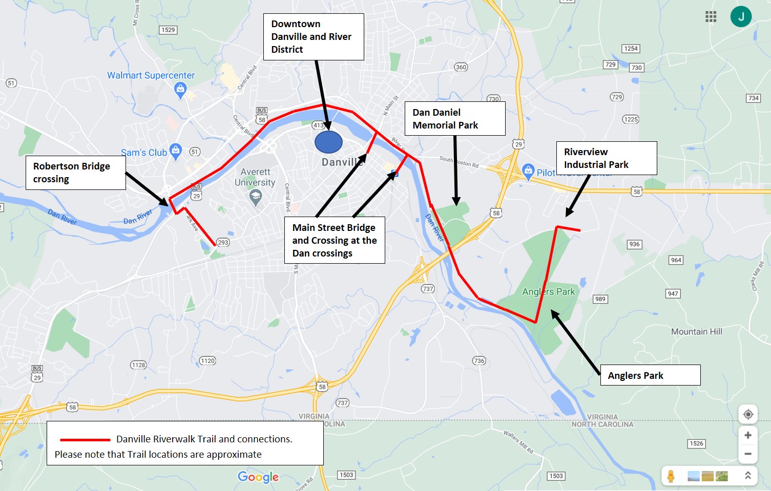
Danville’s resurrected downtown and dynamic River District serve as the home of many new residences, and new as well as established restaurants, businesses, and office locations. The Danville Riverwalk Trail is the ideal means of traveling to and from this business and residential center from either the east or west, and downtown and the River District are linked by this crown jewel much like a pendant on a necklace. Additionally, two of Danville’s greatest recreational assets, Dan Daniel Memorial Park and Anglers Park, are linked together by this trail, much like the beads of a necklace. The Riverwalk Trail also serves one of Danville’s industrial parks, the Riverview Industrial Park, located on the east end of the city. This trail serves the city well, linking not only the downtown/River District, the Riverview Industrial park, and multiple recreational facilities together, but is in close proximity to many of the city’s residential areas. One such area that comes to mind is the collection of neighborhoods located in north Danville, just north of Riverside Drive. From here, cyclists can access the Riverwalk Trail very easily. The trail is also accessible from the city’s Schoolfield neighborhood. From here, one would need only to travel northbound a short distance on Park Avenue to the nearby Robertson Bridge, which incorporates a separated bike/pedestrian lane, and which connects directly to the Danville Riverwalk Trail on the north side of the Dan River. From here, neighborhoods to the north of Riverside Drive, Dan Daniel Memorial and Anglers Parks, as well as the Riverview Industrial Park, can all be easily accessed. The map below shows the approximate location of the Danville Riverwalk Trail, its river crossings, and popular destinations linked together by this trail.
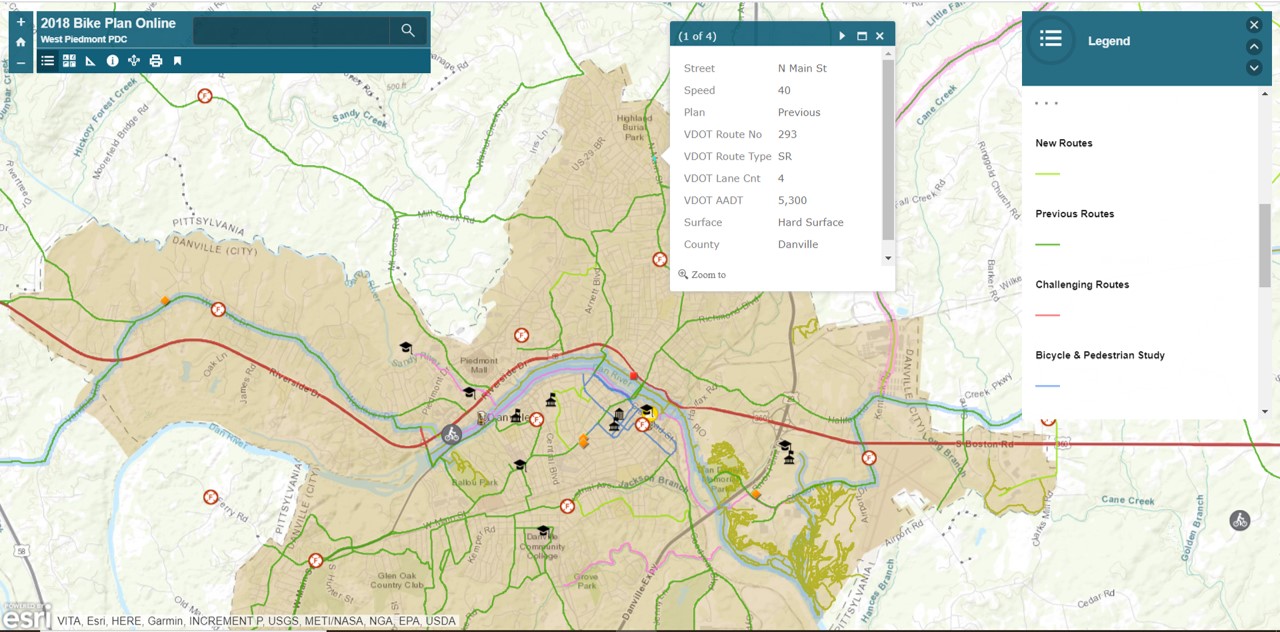
The following figure illustrates recommended routes articulated in the West Piedmont Regional Bicycle Plan, adopted February 2018. As shown in the legend, the light green routes are those that were most recently added, the darker green represents those that were carried forth from the previous plan, and the blue lines in the heart of the River District represent recommended bicycle improvements advanced within the Danville River District Bicycle and Pedestrian Study, adopted by the Danville Metropolitan Planning Organization (MPO) in May 2017, available for viewing at http://www.wppdc.org/content/wppdc/uploads/PDF/transportation/corridor_studies/danville_river_district_bicycle_and_pedestrian_plan_5-8-17.pdf. The routes found within the Regional Bicycle Plan are clickable, and as shown by the pop-up menu in the above figure, they provide information about each particular route segment, such as posted speed limit; average daily traffic volume, expresses as Annual Average Daily Traffic (AADT); the number of travel lanes; and road surface type. The West Piedmont Regional Bicycle Plan interactive map is available at https://wppdc.maps.arcgis.com/apps/View/index.html?appid=abfe3df1b6ec4769aff2253d528fe2e9&extent=-80.3966,36.5503,-79.3420,37.0073.
West Main Street
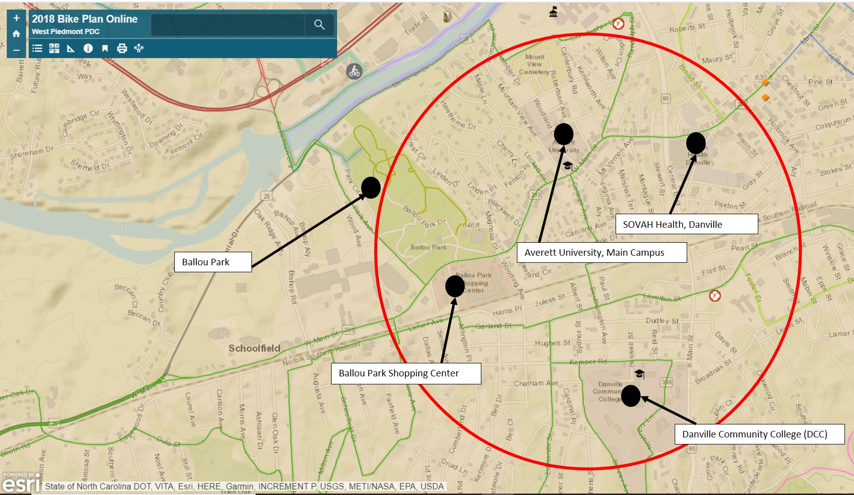
Located just west of downtown and the River District is a collection of residential neighborhoods interspersed with community and regional destinations including SOVAH Health – Danville (formerly Danville Regional Medical Center), Averett University’s Main Campus, the Ballou Park Shopping Center, Ballou Park, and the Danville Community College (DCC) campus. This section of the city is ideal for bicycling, as the road system is comprised largely of residential streets with low traffic volumes and speeds. Furthermore, a 0.65-mile segment of West Main Street, an arterial roadway serving the area, incorporates on-road bike lanes from just east of Ballou Park Shopping Center to the Central Boulevard interchange, enhancing bicyclists’ safety and comfort along this corridor. Furthermore, the Danville Riverwalk Trail can once again be accessed via the Park Avenue/Robertson Bridge connection, noted earlier.
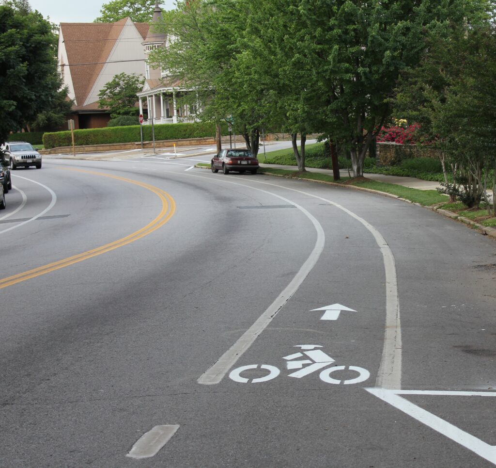
This image, looking east along West Main Street, shows bike lanes on both sides of the street, contributing to safety and comfort of bicyclists.
Ballou Park may also be used as a cut-through by bicyclists who may not feel as comfortable riding on city streets. This combination of facilities serves as a comprehensive bicycle network, providing access to a variety of important community and regional resources and destinations. The image below, again, taken from the interactive map of the West Piedmont Regional Bicycle Plan, illustrates an overview of the area, including recommended bicycle routes, streets, and prominent destinations.
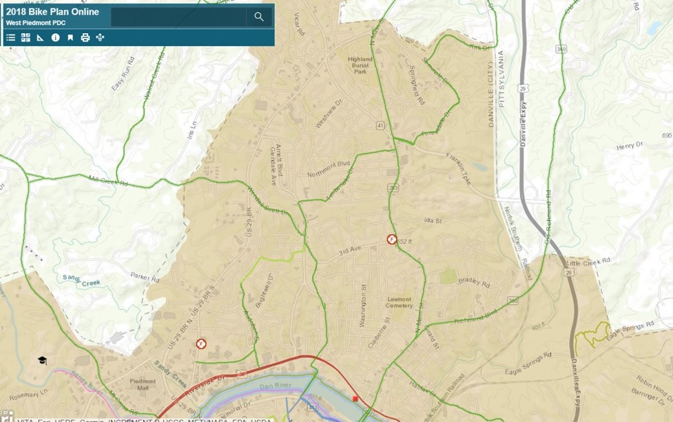
North Danville
North Danville is another prominent part of the city which is comprised of numerous neighborhoods, a number of smaller, neighborhood-oriented business establishments, an elementary school and a middle school, as well as a plethora of places of worship. North Main Street, characterized by moderate traffic volumes and posted speed limits in the 25 – 40 MPH range, provides a relatively comfortable setting for bicyclists. The West Piedmont Regional Bicycle Plan recommends several streets in Danville’s northern section, one of which includes North Main Street. The other recommended streets in this area of the city, some of which intersect North Main Street, also offer cyclists comfortable and safe experiences, with many having posted speed limits in the 25 MPH range. The figure below illustrates the recommended bicycle routes in North Danville, as contained in the West Piedmont Regional Bicycle Plan’s interactive map.
The information above consists of some of the more prominent and populated areas of Danville, though there are many other areas in the City that may be discussed at a later date. The information presented herein serves as a guide for bicyclists who may wish to use their bikes to either commute or take trips for which they may otherwise drive; non-commute trips may include those for shopping, medical appointments, recreation, visiting friends or relatives, etc.
If you currently bicycle as part of your commute or to make other trips, don’t forget to log each trip into the RIDE Solutions app, where you will earn points toward great rewards each time you log a trip! The app can be downloaded for FREE at ridesolutions.org! If you have any questions or comments about bicycling, contact me, Joe Bonanno, at either (276) 638-3987 or at [email protected].