

Last year, 2018, marked the third round of Smart Scale project submissions by localities and regional entities throughout Virginia. Draft project scores were published this past January, and the final scores were released just last month, at which time the Commonwealth Transportation Board (CTB) published the Fiscal Year 2020 Six-Year Improvement Program (SYIP). Once projects are included in the SYIP, they have been selected for funding.
The purpose of Smart Scale is to effectively assign scarce taxpayer funds to the most needed transportation investments in the Commonwealth of Virginia. This is done by scoring project applications based on five criteria in our region, which include the following:
- Economic development
- Safety
- Accessibility
- Congestion mitigation
- Environmental impact
Smart Scale projects selected for funding in the West Piedmont Planning District and subsequently included in the 2020 SYIP include the following:
Danville Metropolitan Planning Organization (Danville MPO)
- Berry Hill Connector Road: This project will involve the construction of an approximately 2.3-mile connector road between the Oak Ridge Farms Road interchange at Danville Expressway (U.S. Route 58/29) and Berry Hill Road (U.S. Route 311) in the vicinity of the Berry Hill Industrial Park, which is currently under development. The connector road will provide a much more direct connection between the Danville Expressway and the Berry Hill Industrial Park than currently is available. In the absence of the connector road, traffic associated with the industrial park would be required to continue farther north on the Danville Expressway to Martinsville Highway (U.S. Route 58 Business), on which it must travel for 0.3-mile, before doubling back on Berry Hill Road for at least 2.5 miles until it reaches the industrial park. Therefore, the connector road will provide a more direct route for freight and employment-related traffic traveling to and from the Berry Hill Industrial Park, while keeping this traffic off of other area roadways.
The connector road will also include two paved eight-foot shoulders which will be able to be utilized for bicycling. The funding of a bus shelter has also been included in this application, to promote transit at the Berry Hill Industrial Park, once jobs arrive.
Franklin County
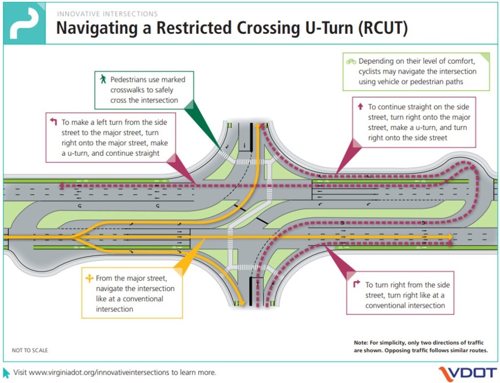
- Improvements to U.S. Route 220 and Pleasant Hill Road/Sontag Road (Route 619): Construction of a “Restricted Crossing U-Turn” (R-CUT) (innovative) design at U.S. Route 220 and Pleasant Hill Road, which will include median separation and the requirement that drivers wishing to turn left onto U.S. Route 220 first turn right and then loop around at a new U-Turn facility. A southbound left-turn lane will be included in this design. A separate R-CUT configuration will also be constructed at the nearby intersection of U.S. Route 220 and Sontag Road. In contrast to a traditional intersection, an R-CUT does not permit traffic to directly turn left from a minor road onto a major road. Rather, the traffic would turn right and perform a U-Turn at a designated location to the right of the minor approach at the intersection. This configuration promotes safety, as it prevents left turns at the intersection, thereby eliminating the need for left turning vehicles to cross two-directional traffic. This configuration also saves drivers time and promotes more efficient use of the roadway.
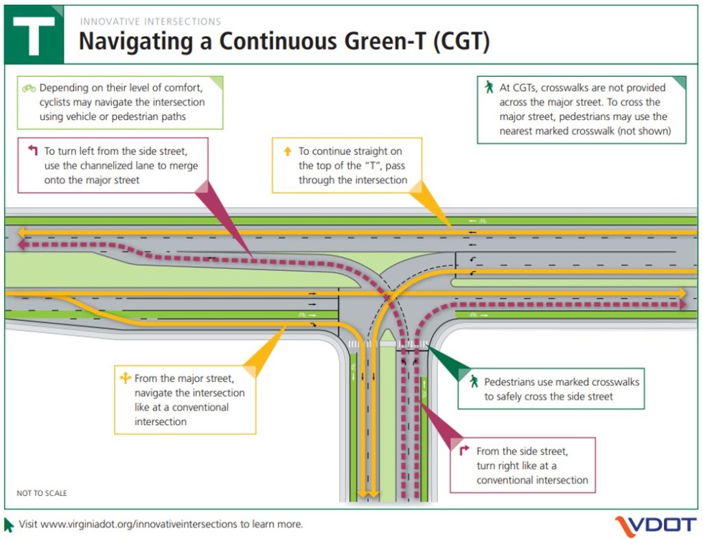
- Improvements to U.S. Route 220 and Grassy Hill Road (Route 919): This project will include the construction of a non-signalized Continuous Green-T design at this intersection. A Continuous Green-T is a design configuration in which traffic entering a major road from a minor road turns right as in a traditional intersection; however, left-turning traffic, when crossing the median of a major roadway, enters the traffic stream via a form of an acceleration lane to enhance safety. The project will also include an extension of the existing acceleration lane on U.S. Route 220 North, a conversion of a driveway along U.S. Route 220 North to right-turn only, and a right-turn lane at this driveway.
To learn more about innovative intersection designs noted above, as well as other efficient configurations, please visit http://www.virginiadot.org/innovativeintersections/.
- Improvements to Booker T. Washington Highway (Route 122) and Lost Mountain Road (Route 636): This project will include the addition of right– and left-turn lanes with median separation at the intersection of Route 122 and Lost Mountain Road. Also to be included in this project will be the construction of median-separated right– and left-turn lanes on Route 122 at the Booker T. Washington National Monument, and a multi-use path along Route 122 to provide opportunities for active transportation and exercise between Lost Mountain Road and the Westlake community. Access management will also be a component of this project.
Patrick County
- Claudville Highway Intersection Improvement: This project will improve safety at the intersection of Claudville Highway (Route 103) and Hatcher’s Chapel Road / Archie’s Creek Road (Route 645). Specifically, the project will involve the reduction in the height of a grade just east of the intersection along Route 103, enabling better sight distance for drivers entering Route 103 from Hatcher’s Chapel Road. The project will also trim back terrain along Route 103 to the east of the intersection to improve sight distance for drivers turning off of Archie’s Creek Road onto Route 103.
Pittsylvania County
- S. Route 29 and Shula Drive (Route 642): This project, located in northern Pittsylvania County, south of Hurt, will involve the relocation of the western portion of the intersection of Shula Drive further south along U.S. Route 29, while leaving the eastern segment of the intersection in its current location. This intersection has experienced a number of serious crashes involving vehicles crossing U.S. Route 29, and it is anticipated that relocating the western part of this intersection southward will dramatically increase safety at this location.