As was revealed via a press release two weeks ago, RIDE Solutions has partnered with Agile Mile to offer an automatic ride-matching app, which is a very effective means by which carpoolers throughout the region can connect with one-another. This new system, which offers points toward rewards when users log trips, will soon expand its scope of modal transportation options.
RIDE Solutions administrators are currently working to integrate regional transit service into the app to enable workers (and others who want to utilize green modes of travel) to log trips via transit. This new modal option will be able to be utilized separate from, or in conjunction with, the carpooling option.
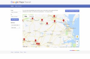
Transit will be incorporated into the RIDE Solutions app via the Google Transit platform. Google Transit already serves as a stand-alone online transit resource, which is integrated into Google Maps, and can be very useful for those with mobile devices or PCs. For those who wish to use Google Transit in its stand-alone context, simply do a Google search for Google Transit, or navigate to https://maps.google.com/landing/transit/index.html. Once at the main page, you will be shown a map of the world. At this point, you can zoom in to a city to determine whether its transit system has been included in Google Transit, which will be indicated by a red point (see below).

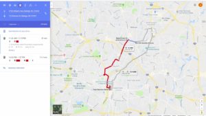
Next, you can zoom closely into the city you plan to travel within via transit. Let’s say you live near 3700 Atlantic Avenue in Raleigh, NC, and wish to take a trip by transit to the State Capitol Building, which is located at 1 E Edenton St in Raleigh. On your mobile device, you will enter the starting address (3700 Atlantic Avenue, Raleigh, NC), and enter your destination address in the space just below (1 E Edenton St, Raleigh, NC). On mobile devices, these queries are located below the map, while on PC platforms, they are located to the left of the map. Next, you will press “Get Directions.” A close-up map will appear with your route generated. A solid red line on the map indicates the recommended transit route, while a blue dotted line indicates the route you must walk or bike in order to access the transit service (see below).

One transit option in the West Piedmont Planning District is Piedmont Area Regional Transit (PART), which serves the City of Martinsville and Henry County. This service operates three routes in the city and portions of the county Monday – Friday on a deviated fixed-route (up to ¾-mile off the main route) basis. More information about the PART system can be obtained at http://www.martinsville-va.gov/residents/bus-system-p-a-r-t. Danville Transit currently serves the City of Danville via multiple routes throughout the city, Monday – Saturday. The system consists of a fixed route service, a Dial-a-Ride service which provides individual door-to-door service, and a Handivan service for users with disabilities. Later this year, Danville Transit has plans to expand service along the U.S. Route 29 corridor north to the Town of Hurt in Pittsylvania County, and east along the U.S. Route 58 corridor, to Halifax County. For more information about Danville Transit, please visit https://www.danville-va.gov/508/Mass-Transit. The Ferrum Express, a component transit route of RADAR (Roanoke Area Dial-a-Ride) of Roanoke, currently offers Thursday and Friday service between the Village of Ferrum and the Town of Rocky Mount in Franklin County, and Saturday service between Ferrum, Rocky Mount, and Roanoke. More information about this service can be found at https://radartransit.org/ridership-information/college-express/.


