

For years, Patrick County had awaited reconstruction of a portion of U.S. Route 58 between Stuart and Meadows of Dan as a means to improve the safety and functionality of this arterial roadway. The wait is over! A ground-breaking ceremony was held in Patrick County in early October to mark the beginning of the project which will dramatically reconfigure this western segment of U.S. Route 58. This event followed a robustly-attended public information “Pardon Our Dust” meeting in Stuart in August to bring citizens and other stakeholders up-to-date on the project and its timeline.
The project entails the widening of 7.4 miles of U.S. Route 58 from two to four lanes from just west of the Town of Stuart to just east of Cloudbreak Road (Route 610), located just east of Vesta. The reconstructed roadway will also be median-separated, greatly contributing to travel safety along the mountainous segment.
The center medians will be configured differently, depending on the section of roadway. The western-most segment, extending from just east of Cloudbreak Road to about 0.75-mile east of the Lovers Leap overlook, will consist of an 18’ grassy median. From 0.75-mile east of the overlook to 0.25-mile east of DeHart Botanical Garden, the median will consist of a simple concrete barrier surrounded by generous center-shoulder space. From 0.25-mile east of DeHart Botanical Garden to the intersection of Central Academy Road/Trot Valley Road (Route 640), the median will actually consist of forested land of varying width. From the Route 640 intersection to the terminus of upgrades just west of Stuart, a four-foot paved area will constitute the median.[1]
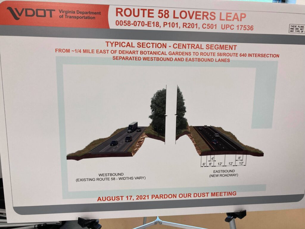
Photo of a display board showing a planned road configuration along one of the segments.
Another very prominent component of this project will be a complete redesign of the Lovers Leap overlook. Currently, the overlook consists of little more than a wide roadway shoulder. However, the new overlook will consist of a parking and viewing area separated from U.S. Route 58, which will enable visitors to safety stroll without the possibility of conflicts between parked vehicles and through-traffic. This component will not only address current safety and vehicle capacity issues, but is also likely to increase tourism by creating a more inviting viewing area.
While the widening of U.S. Route 58 to four lanes with median separation will constitute the main elements of the project, adequately-wide shoulders will be included as well. All westbound segments will include eight-foot wide paved shoulders, while two of the four eastbound (downhill) segments will be served by four-foot shoulders, and the other two segments comprising eight-foot shoulders. These shoulders will improve safety and comfort for the roadway’s vehicular users by providing an extra margin of safety or a place to pull over during a vehicle breakdown or other emergency. The installation of shoulders is significant from the perspective of multimodal transportation because they will provide additional space for bicycling, some of which already takes place on this mountainous portion of roadway, despite the lack of shoulders in many areas. It is likely, then, that with more adequate shoulder space, cyclists intent on conquering challenging topography will be more likely to ride this segment of roadway. Furthermore, shoulder provisions will make it safer and more practical for bicyclists to ride from the Blue Ridge Parkway to destinations such as Fred Clifton Park and Lovers Leap overlook.
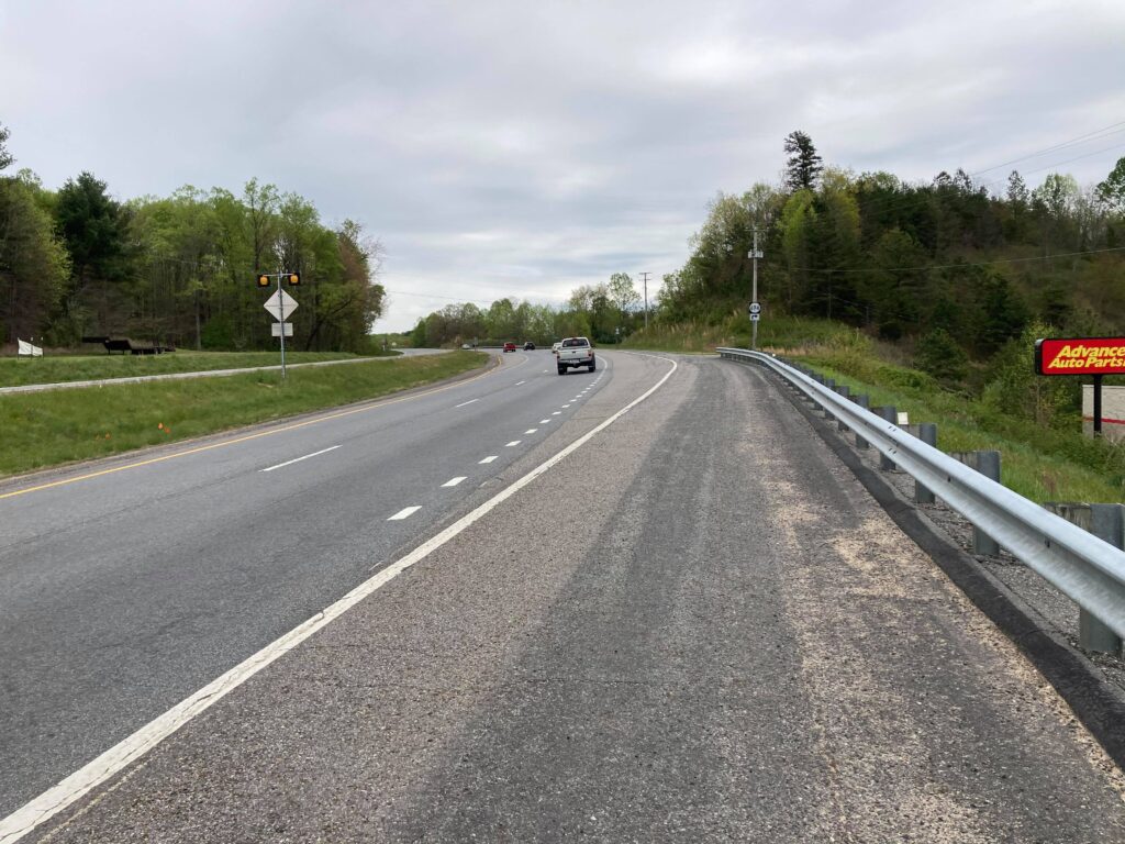
An example of a wide shoulder that I used for bicycling along a segment of U.S. Route 58 near Stuart.
For some background on this project, the work currently taking place along this segment of U.S. Route 58 had its origin in 1989 with the Route 58 Corridor Development Program, developed by the Virginia General Assembly, the goal of which was to promote economic development throughout southern Virginia, much of which is rural. The entire length of the U.S. Route 58 corridor is 680 miles. At the program’s conception, only 240 miles of roadway consisted of at least four lanes, while that figure now stands at 370 miles.[2] An additional goal of the program is to improve connectivity from the West Piedmont Region west to Interstate 77 in Hillsville. The $300 million project currently under development will also improve access between the Port of Virginia, Interstate 77, and points in between. For that section of U.S. Route 58 between the West Piedmont Region and I-77, just over seven miles will remain two lanes (both in Carroll County), according to my Google Earth measurements.
U.S. Route 58 construction will continue for several years, and is scheduled to be completed in spring 2026. During the August public meeting that I attended in Stuart, it was noted that delays and detours would take place periodically for the duration of construction. For instance, blasting and drilling of rock will likely result in short-duration road closures, perhaps 15 to 20 minutes at a time. Additionally, the road will at times be reduced to one lane, and traffic will be controlled by temporary traffic signals. Therefore, individuals who travel this corridor over the next several years are encouraged to provide themselves extra travel time.
If you’d like to learn more about this project, please visit the project website, which is https://www.virginiadot.org/projects/salem/route-58-widening—lovers-leap-in-patrick-county-ppta-project.asp.
Whether your commute or other essential trip involves carpooling, transit use, biking, or walking, or if you telework, don’t forget to log your trips in the RIDE Solutions app to earn points which you can apply to shopping, dining, activities, services, or the opportunity to enter raffles for chances to win great prizes such as gift cards! Download the app today for FREE at ridesolutions.org!
Have a wonderful holiday, everyone!
[1] “’Pardon Our Dust’ Meeting. Route 58 Improvements – Patrick County.” PowerPoint Presentation, Virginia Department of Transportation/Branch Civil. August 2021. https://www.virginiadot.org/Projects/Salem/asset_upload_file373_170418.pdf.
[2] “U.S. Route 58 Corridor Development Program.” Virginia Department of Transportation. November 1, 2019. https://www.virginiadot.org/projects/Rt58-overview.asp.