

With the temperatures getting cooler and the air much less humid than just a few short months ago, now is a great time to get out on your bike, whether to commute to work or ride to your local store without breaking much of a sweat, or just to venture out to view the fall colors before they disappear for the winter. While our region is currently at peak or perhaps just beyond, there still may be some time to enjoy these beautiful colors. In this blog, I will suggest some routes for you to ride this fall to catch a good ride while the weather is still nice and crisp. The West Piedmont Regional Bicycle Plan is a great resource to help you plan your trip. Before I get into the various places to ride, I’d like to introduce you to some features of our interactive bike plan.
West Piedmont Regional Bicycle Plan
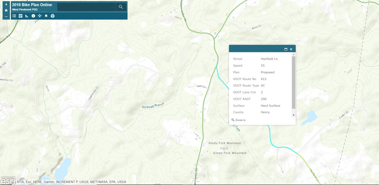
The updated West Piedmont Regional Bicycle Plan was adopted in February 2018, and features an interactive bicycle element which allows you to explore various characteristics of various road segments that you may be interested in riding. The green lines superimposed over the roads represent recommended bicycle routes, which cyclists can ride and localities can integrate into their local plans. When you click a segment of the these routes, a menu will pop up which indicates the posted speed limit; the road surface material; and the daily traffic volume, expressed as AADT (Annual Average Daily Traffic). The map also features destinations which can be clicked on; once you click on one of these destinations, information about the destination will appear in a menu. The interactive map of the West Piedmont Regional Bicycle Plan is available at https://wppdc.maps.arcgis.com/apps/View/index.html?appid=abfe3df1b6ec4769aff2253d528fe2e9&extent=-80.3966,36.5503,-79.3420,37.0073. See an example of the interactive map below.
City of Danville
The City of Danville is blessed with numerous places to bicycle, whether you plan to do on-road, paved path, or mountain biking. A great ride this time of year is the 9+ mile Danville Riverwalk Trail, which is covered in tree canopy for much of its length and offers great views of the Dan River. What’s more, there are numerous connections across the Dan River to get to the Danville River District, where you’ll be able to stop for a cup of coffee, a meal, or to browse through one of many of the District’s boutique shops. Information about the Danville Riverwalk Trail can be found at https://www.danvilleva.gov/2035/Danville-Riverwalk-Trail.
The City is also home to the award-winning Anglers Park mountain bike trails which, according to the Anglers Ridge Trail Association, number more than 35 miles! Learn more about Anglers Ridge mountain bike trails by visiting https://www.danvilleva.gov/2030/Anglers-Ridge-Mountain-Bike-Trail-System, which offers some information, as well as a link to a trail map. Neighboring Dan Daniel Memorial Park also offers trails for mountain biking enthusiasts, information about which can also be found within the link immediately above.
City of Martinsville/Henry County
The City of Martinsville offers a number of opportunities for cyclists to get out into the outdoors – right in the city! The Dick & Willie Passage Trail is a great opportunity to do this and, like the Danville Riverwalk Trail, much of it is covered by a tree canopy. The Dick & Willie is currently divided into two sections, with the original section extending about 4.5 miles on an old railroad bed from Virginia Avenue (U.S. 220 Business) near Walmart to Mulberry Creek, on the east end of the City. This section of trail will bring cyclists through quiet, wooded areas of Martinsville, along with some neighborhoods. There is also a spur on along this trail which will bring you directly to uptown Martinsville, where you can stop to eat at any number of restaurants, stop at the City’s farmers’ market, visit a museum or the historic Henry County Courthouse, or browse in one of uptown’s many stores.
A newer, 2.7-mile segment of the Dick & Willie, which is not yet linked to the original segment, is a wonderful option for bicyclists, and is not quite as challenging as the original section of trail due to its tamer topography. You can begin at the Smith River Sports Complex, located just east of the City of Martinsville, alongside Irisburg Road. The trail begins toward the back (south) end of the Complex and will take you along the Smith River, through wooded areas, through a residential neighborhood (on-street segment), and finally alongside Mulberry Creek, before ending at a trailhead along Spruce Street.
While traffic levels are relatively high in Henry County close to the City of Martinsville, the County offers some great opportunities for bicycling in its outlying areas. The West Piedmont Regional Bicycle Plan has established the Beaches to Bluegrass Priority Corridor, which generally shares the right-of-way of the planned Beaches to Bluegrass Trail developed by the Virginia Department of Conservation and Recreation (DCR). This trail was developed by DCR as a state recreational route extending from Cumberland Gap, Tennessee east to Virginia Beach. Here in the West Piedmont Region, this trail passes through Henry County from west to east. A great ride with relatively low traffic volumes extends along part of this route in the County east to the Pittsylvania County line. Park at the Smith River Sports Complex and ride east along Irisburg Road until you arrive at Axton Road, where you will turn right onto Axton Road for about 0.3-mile until you come to Cascade Road, at which you can turn left; just beyond this point is the Pittsylvania County line. This route is just over nine miles one way, from the parking lot of the Smith River Sports Complex.
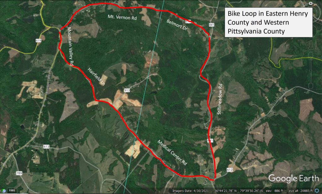
Split between northeastern Henry County and a small sliver of Pittsylvania County is a loop route which is a bit shorter than the Beaches to Bluegrass Priority Route noted above. The western part of this route comprises a small segment of Mountain Valley Road and transitions to Hairfield Lane which becomes Medical Center Road across the county line in Pittsylvania County the 8 miles. From there, turn left onto Wyatt Farm Road for only about 300 feet, and then turn left again onto Stillmeadow Road. From there, ride Stillmeadow Road for 2.15 miles until you arrive at Belmort Drive, where you’ll turn left. After a short distance, Belmort Drive becomes Mount Vernon Road once you again cross the county line to return to your starting point in Henry County. The nice thing about this circuitous route is that the traffic volumes are extremely low along most of its length, the topography is not all that hilly, and you’ll ride through mostly rural-residential and agricultural land. A church with a large parking lot is located at the intersection of Mount Vernon Road and Mountain Valley Road. See below a map of the route.
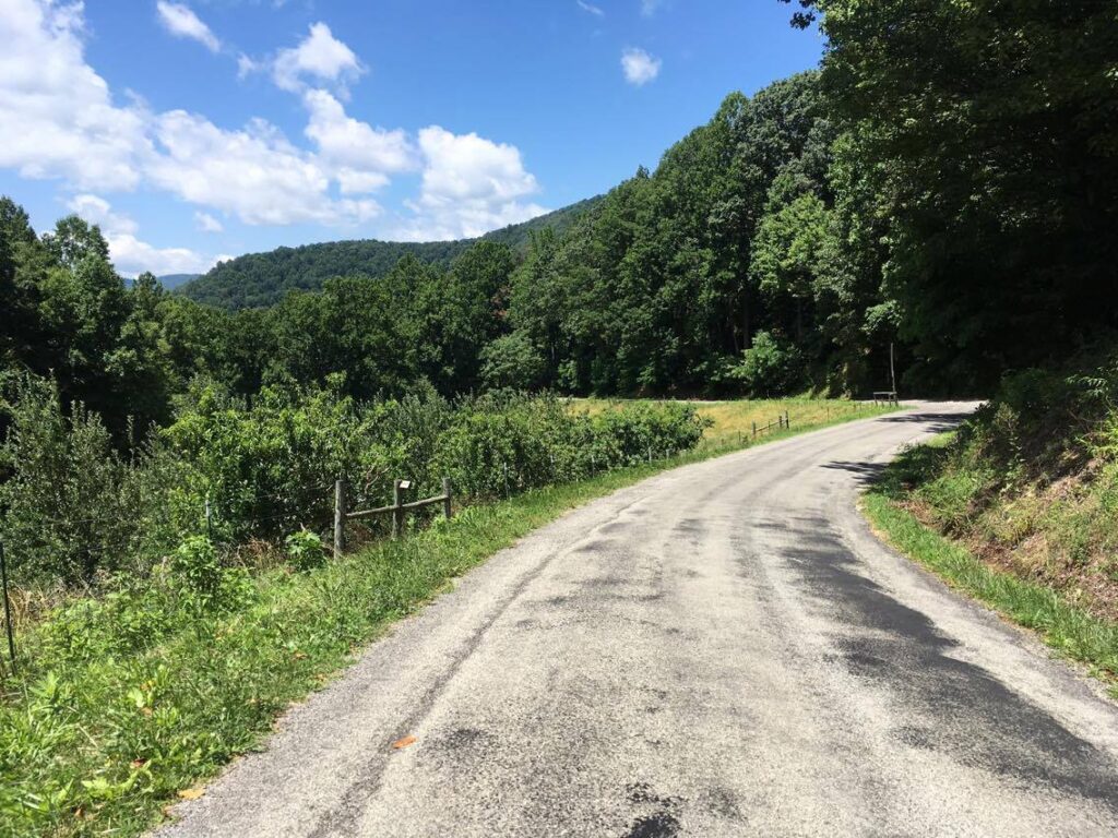
Hairfield Lane, in eastern Henry County, provides the cyclist with great views of the countryside in a low-traffic and relaxing setting.
Franklin County
Franklin County is known for its rural character along with its unique population centers such as Rocky Mount, Ferrum, and Westlake Corner. The West Piedmont Regional Bicycle Plan has designated the Western Franklin County Priority Zone as an ideal location for bicycling in the County due to the area’s low traffic volumes resulting from the low population density, the scenic views, and rural character. This Priority Zone is located predominantly west of U.S. Route 220 to the western boundary of the County. A nice ride in this area that I can recommend is Wades Gap Road north from its intersection with Dillons Mill Road. If you’re driving to this area, a great place to park, and where I was told cyclists are able to park, is Monte Vista Church, located at the intersection of Wades Gap Road and Dillons Mill Road. Biking north on Wades Gap Road, you can take a breather or stop for lunch at a picnic shelter with tables and a playground for the kids, which is owned by the same church, is open to the public, and located about 1.4 miles north of Wade Gap Road’s intersection with Dillon’s Mill Road. Another great option when biking north along Wade’s Gap Road is to turn right onto Webster Corner Road, which is about one mile north of the intersection with Dillon’s Mill Road. From here, Webster Corner Road loops back to Dillon’s Mill Road, where you will make a right, bringing you back to the church parking area. You can learn more about the Wades Gap Road route by visiting https://ridewithgps.com/routes/34775492.
Wades Gap Road, with its narrow geometry, low traffic volumes, and outstanding scenery, is a great place to ride any time of the year.
For the more rugged rider, Waid Recreation Park offers a number of off-road mountain bike trails for mountain bicyclists of various skill levels. Waid Recreation Park is located off of 6 Mile Post Road, just southwest of Rocky Mount. Please see https://www.playfranklincounty.com/Facilities/Facility/Details/Waid-Park-2 for more information about Waid Recreation Park.
Patrick County
Two really nice rides in Patrick County both begin in Patrick Springs, at Patrick Springs Park, located off of Mountain View Loop. The first will take you to Stuart, and is well-suited for intermediate or advanced riders. From Patrick Springs Park, turn right onto Mountain View Loop and then left onto Spring Road until you arrive at the intersection of U.S. Route 58. From there, continue south onto South Mayo Drive until you reach New Hope Church Road, onto which you’ll turn right. This road will provide you a nice view of farms and the South Mayo River, until you reach Poplar Drive, onto which you’ll turn left. From here, you’ll ride Poplar Drive for a very short distance, until you arrive at Commerce Street, onto which you’ll turn right. Commerce Street will take you right into downtown Stuart, though you may wish to turn off onto the Mayo River Rail Trail located opposite Developmental Road, as traffic in town tends to pick up. The entire trip one-way is 5.8 miles. From there, you may want to head into town and get something to eat and browse some of the shops. 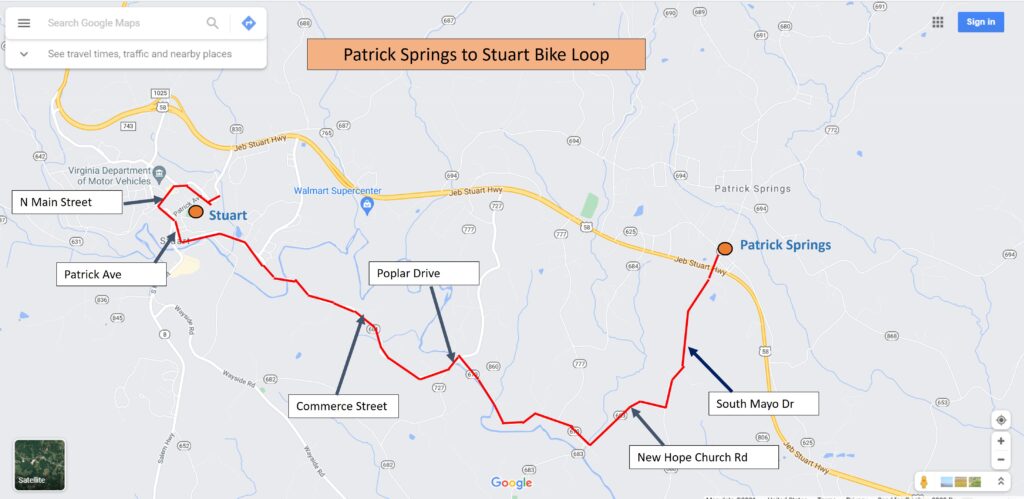
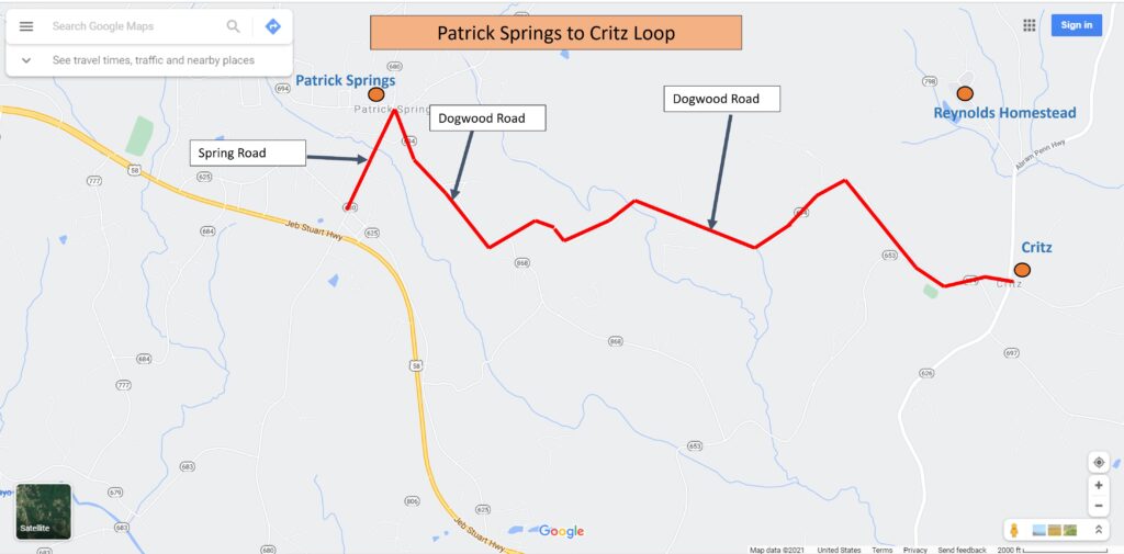
The next route, which allows you to travel between Patrick Springs and Critz, is much shorter and is more ideal for beginner or intermediate riders. Start out once again at Patrick Springs Park and turn right onto Mountain View Loop. Once you arrive at Spring Road, turn right and continue until you arrive at Dogwood Road, onto which you’ll turn right. Continue straight on Dogwood Road until you arrive at Critz. Once at Critz, you can ride around and view some of the structures that were likely there when the Dick & Willie Railroad passed through the community. Or, you can turn left onto Abram Penn Highway and ride a short distance to the historic Reynolds Homestead to explore the grounds or just relax and enjoy all the outdoors have to offer. See below a map of the route.
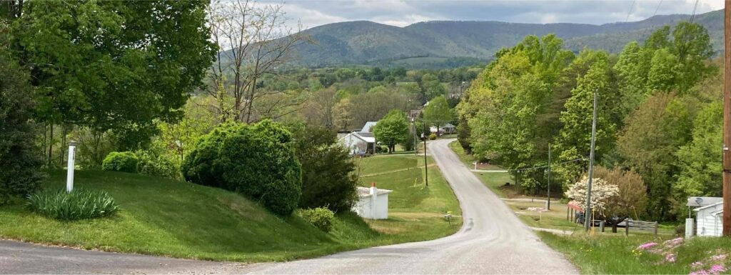
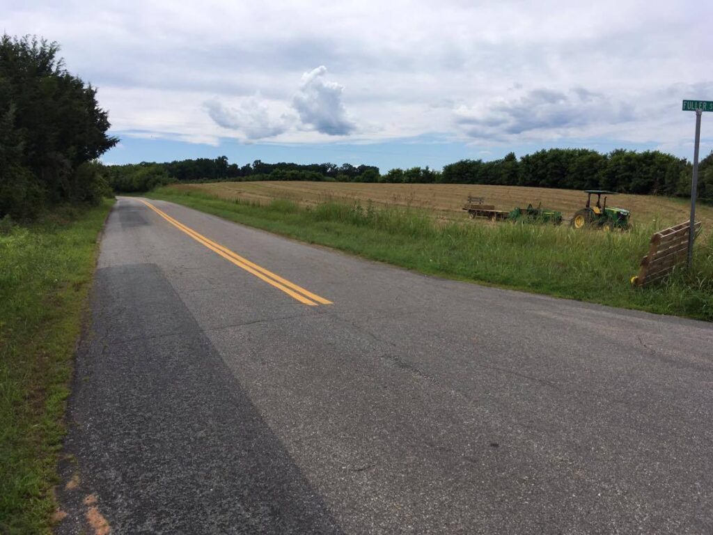
View along Dogwood Road, looking west.
Pittsylvania County
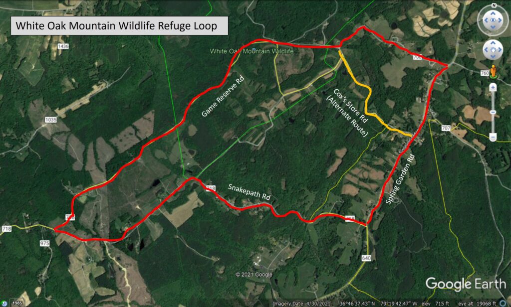
A nice “back-country” route that would be fun to ride in Pittsylvania County is in the White Oak Mountain area and consists of an approximately 8.6-mile loop comprising Game Reserve Road, Spring Garden Road, and Snakepath Road. Game Reserve Road passes through the White Oak Mountain Wildlife Refuge, so there may be great opportunities to spot wildlife, as well as view the remainder of this year’s foliage. Public parking is available at various places along the eastern portion of Game Reserve Road. A very good aspect of this loop route is that most of the road segments including Game Reserve Road and Snakepath Road are characterized by exceptionally low traffic volumes. By contrast, the 1.6-mile segment of Spring Garden Road accommodates higher traffic volumes, which may be in the range of about 1,200 vehicles per day, but is still not exceptionally high. Spring Garden Road does not have shoulders, so use caution when riding this segment. If you would prefer to bike on Spring Garden Road for a shorter distance, you can ride Cox’s Store Road, which links Game Reserve Road to Spring Garden Road, rather than riding along Game Reserve Road to its northern-most end. Using this alternate route, you’ll ride on Spring Garden Road for about 0.85-mile, as opposed to the full 1.6 mile. In total, using the Cox’s Store Road alternative will only trim about 0.7 miles off the entire loop route. In terms of route planning, I must let you know that bikes with skinny tires may not be ideal for this route, since about half of it is not paved, consisting of gravel surface. Therefore, bikes with wider or moderate-width tires would be ideal for this route. For more information about White Oak Mountain Wildlife Refuge, including a map, please visit https://dwr.virginia.gov/wma/white-oak-mountain/. And even though “Mountain” is referenced in its name, the area topography is relatively tame and non-mountainous. Please see the map below for an illustration of this loop route.
With the weather getting cooler, now might be a nice time for you to consider bicycling as part of your commute or other essential trip to the store, doctor’s office, etc. Whenever you ride a commute or essential trip, don’t forget that you will earn points toward discounts on shopping, dining, services, or activities; the points can also be redeemed to enter raffles for opportunities to win great prizes such as gift cards. Download the free RIDE Solutions app at ridesolutions.org today!