

When we’re out and about, we typically see other people biking and walking in their neighborhoods, towns, and cities. As a planner, one of the things that fascinates me is where people walk and bike, as this factor is often an important prerequisite for identifying where infrastructure such as bike lanes and sidewalks should be provided. The oldest method to determine this is simple observation. However, as technology has advanced, it has led to the creation of a number of tools which can provide some of this information at a glance. One such tool is the Strava Global Heatmap, which instantly paints a picture of bicycle and pedestrian activity at both the global and local levels.
Strava is an online platform which enables users to track their workout progress, and helps indicate whether they are reaching their fitness goals. The main topic of this blog, however, is another function of Strava – the product’s Global Heatmap. Strava, with the aid of smart phones and GPS devices, can track where individuals engage in various physical activities including bicycling, walking, water sports such as paddling, and winter ski activities. While Strava offers personalized heatmaps, its Global Heatmap offers an aggregation of all users’ activities, offering no information about the users, other than where their physical activities are taking place.
The following image depicts the Strava Global Heatmap in the context of the United States. The red and blue colors you see on the map indicate where people have been engaging in physical activities including bicycling, foot-based activities (walking, running, and hiking), swimming, and winter activities. As might be expected, the majority of the activity takes place in and around our nation’s urbanized areas. Using the query tool on the left, I have set activities to “All,” which indicates the combination of foot-based, bicycling, water-based, and winter sports activities. The red lines indicate routes with significant use, while the thickest red lines indicate lines with the most use (at a zoomed out scale, this is not discernible); the light blue lines indicate areas of less use.
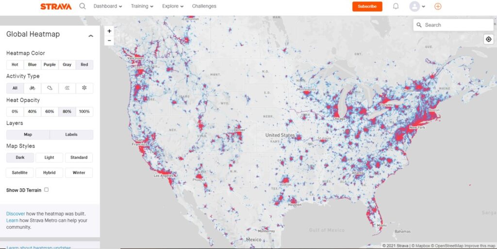
This map view of the U.S. shows that Strava users who engaged in various forms of activities such as walking, running, hiking, bicycling, paddle sports, and outdoor winter sports. The figure shows that most activity took place in and around the nation’s urban areas.
From here, I will focus on foot-based activities and bicycling in some of the more populated areas of our region to indicate where people have been walking, running, hiking, and bicycling. I’ll start out with the Town of Rocky Mount, which is compact enough for walking to many destinations, yet also bikeable. The first map shows foot-based activities in and around the Town, with the greatest amount of activity appearing to take place along North Main Street and Franklin Street in downtown Rocky Mount. The image that follows this depicts bicycling in the Town. Here again, North Main Street appears very popular with cyclists, as is Grassy Hill Road on the north end of town. Franklin Street (Route 40), southwest of town, also registers some activity.
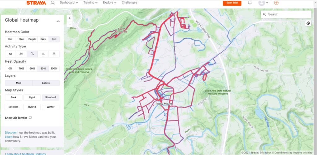
Foot-based activities in the Rocky Mount area.
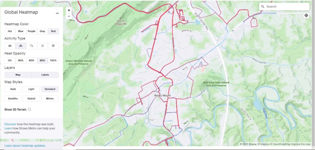
Bicycling activities in and around Rocky Mount.
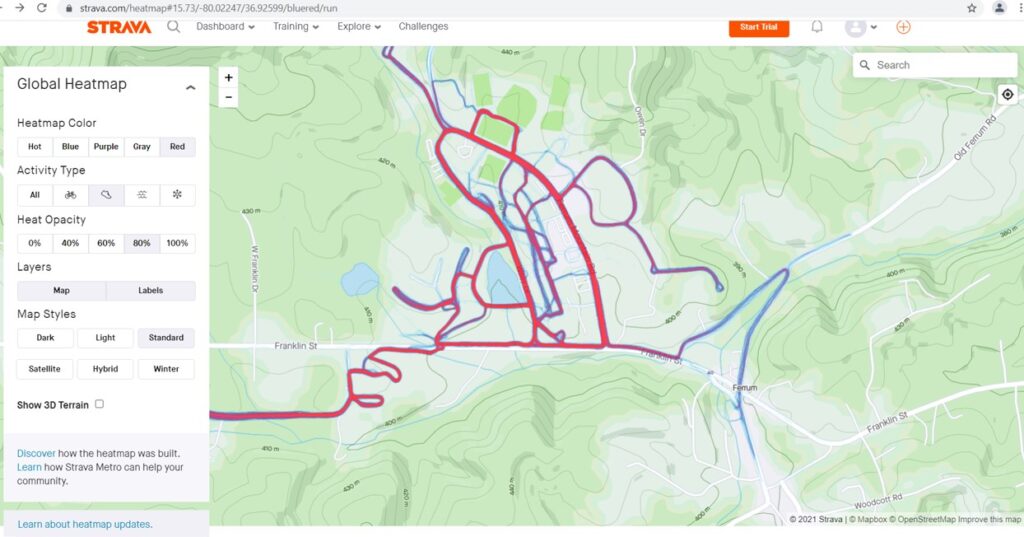
The Village of Ferrum, a popular college town, home to Ferrum College, is, like Rocky Mount, geographically small and able to be navigated by foot or bike. The following image shows that most of the pedestrian activity has taken place around the Ferrum College campus, with Wiley Drive, Ferrum Mountain Road, and Franklin Street appearing to serve as a walking loop. The picture for bicycling, shown on the following image, is a little different, with Wiley Drive barely appearing, while Ferrum Mountain Road appears heavily used. Old Ferrum Road and Ingramville Road both depict moderate use.
This figure shows foot-based activities in the Ferrum community.
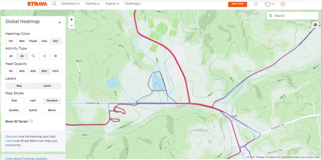
This figure shows bicycling activities in the Ferrum community.
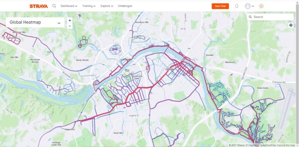
In the City of Danville, walking and running appear to be very popular along South and West Main Street, in the River District, along the Riverwalk Trail, as well as in Anglers Park, Dan Daniel Memorial Park, and Ballou Park. The next image shows that mountain biking appears to be extremely popular at Anglers Park and somewhat popular at Dan Daniel Memorial Park. Conventional bicycling appears popular along the Riverwalk Trail, Memorial Drive, South and West Main Street, Craghead Street in the River District, and along Industrial Avenue and Goodyear Boulevard.
Map of foot-based activities in Danville.

This figure shows where bicycling activities have taken place in Danville.
The City of Martinsville and its immediate surroundings show a significant amount of walking and running activity, with heavily-used areas including uptown Martinsville, Starling Avenue, Indian Trail and Root Trail in the Lake Lanier section of the City. Other popular areas for walking and running include the original section of the Dick & Willie Passage Trail (extending from left to right across the top part of the image) as well as the new portion of that trail out to the Smith River Sports Complex (the southern-most red line). The Smith River Trail, located along the western (left) side of the image, also shows significant use. The bicycling map, which follows the foot-based activities map, shows that both sections of the Dick & Willie Passage Trail are heavily used. Also heavily used are residential streets in the Lake Lanier community. Uptown Martinsville indicates some use, as do many of the roads in the countryside including Irisburg Road, Old Liberty Drive, and Chatham Heights Road.
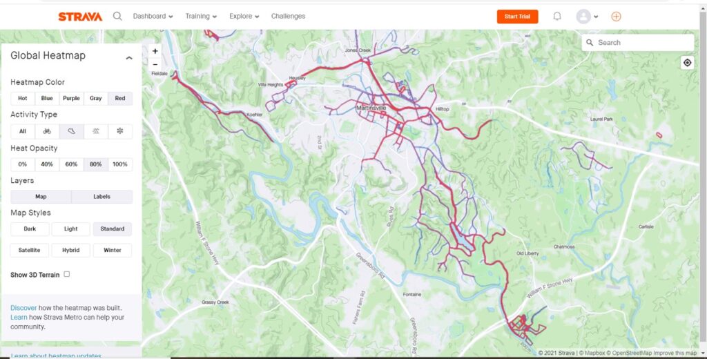
This figure shows foot-based activities in and around the City of Martinsville.
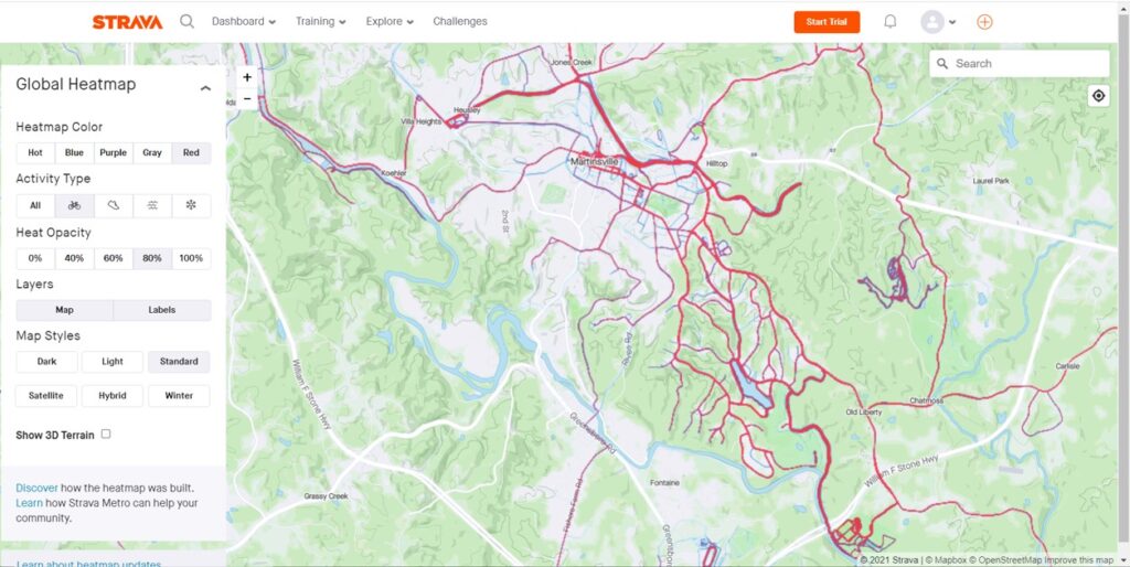
This figure shows popular bicycling routes in and around Martinsville.
Significant walking and running activity is indicated in the Town of Stuart, with popular routes represented by the Mayo River Rail Trail and its spur trail to the north, Dobyns Road, Ayers Drive, West Blue Ridge Street, Sunset Drive, North Main Street, Wood Brothers Drive, and the walking trail at DeHart Park. The image which follows the walking and running map shows bicycle activities in and around Stuart; while bicycling certainly takes place in and around the town, it does not appear to be as prominent as walking and running. That image shows that Poorhouse Creek Road and Dobyns Road are both popular with bicyclists. Additionally, a cycling loop appears to include the network of Ayers Drive, Pine Street, Sunset Drive, West Blue Ridge Street, Wood Brothers Drive, Dobyns Road, and Riverside Drive. Commerce Street and the Mayo River Rail Trail also have exhibited some bicycle activity.
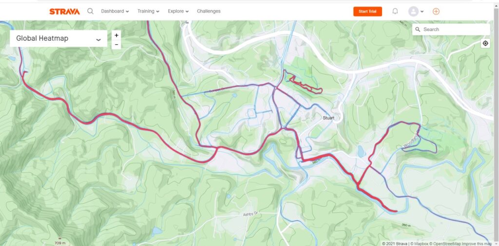
This map shows foot-based activities in and around the Town of Stuart.
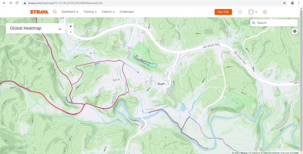
This map shows where people had been bicycling in and around the Town of Stuart.
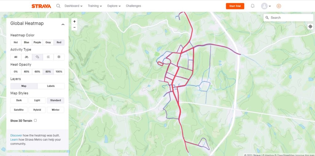
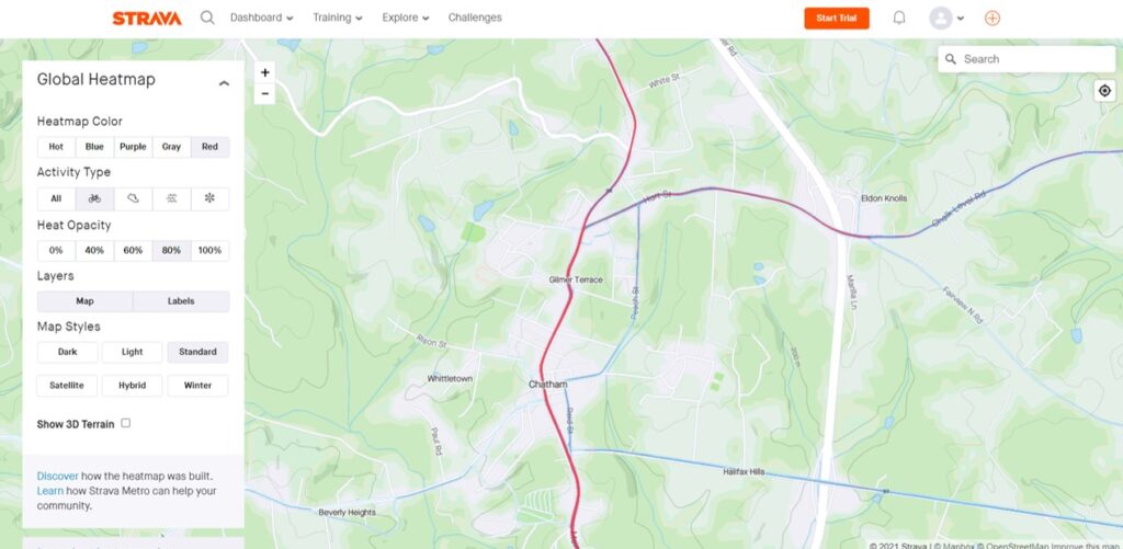
Walking and running appear to be fairly common in the Town of Chatham, Pittsylvania County, with a significant amount of these activities taking place throughout the main core of the town, with Main Street, Hurt Street, and Peach Street among the greatest use. The map which follows shows that bicycling is not nearly as common in the Town, with Main Street serving as the most popular road for cycling, and Hurt Street/Chalk Level Road, Peach Street, and Halifax Road exhibiting some bicycling activity.
Walking and running activities in the Town of Chatham.
Where people bike in and around the Town of Chatham.
The image immediately below shows walking and running activities in the Town of Gretna. Like Chatham, walking is popular throughout much of the Town, as well as at the Gretna High School Track and in an undeveloped area on the southwest side of town. The final map in this blog, depicting bike activities in the Town, reveals a pattern very similar to that in Chatham. Unlike the ubiquitous walking patterns exhibited throughout the Town, bicycling has largely been focused on Main Street and East and West Gretna Road, with few exceptions.
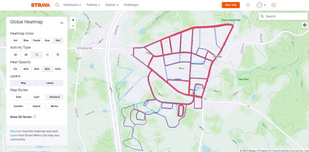
Pedestrian and running activities in the Town of Gretna.
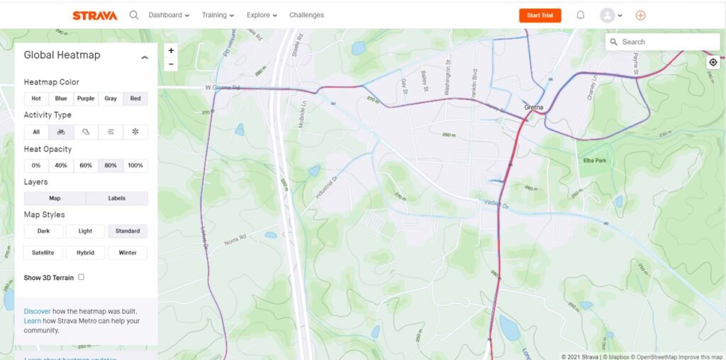
Bicycling activities in and around the Town of Gretna.
If walking and biking are part of your commute or essential trips, don’t forget to log these into the RIDE Solutions app, through which you’ll earn discounts on shopping, dining, activities, and services, as well as opportunities to enter raffles to win great prizes such as gift cards! Download this free app today at ridesolutions.org!