

As the heat of summer wanes and gives way to the cooler temperatures of fall, it might be a great time to try biking as part of your commute or other essential trip. In addition to saving money and wear-and-tear on your vehicle, you’ll be getting a free workout! In some of my past blogs about bicycling, I focused on popular destinations to bike to in cities and towns throughout the West Piedmont Region. In this blog, I will focus predominantly on safe and comfortable routes to bike in the City of Danville, particularly if you haven’t biked in a while and you want to get back into it gradually. Bicycle infrastructure – whether it consists of multi-use trails or bike lanes – is hard to beat in Danville, making the City is very well-suited to this form of transportation.
The Riverwalk Trail
Certainly the most well-known place to bike in the City of Danville is the Danville Riverwalk Trail, which extends more than nine miles, from just west of the intersection of Riverside Drive (U.S. 58 Business) and Central Boulevard (U.S. 29 Business) east along the Dan River to Anglers Park and terminating along Stinson Drive near Danville Regional Airport and Slayton Avenue, located within the Cyber Park business park. The Danville Riverwalk Trail is mostly level from its western terminus near Central Boulevard and Riverside Drive east to Anglers Park, a distance of nearly five miles. North and east of this park, the trail ascends some topography before ending at the Cyber Park and near the Danville Regional Airport. Riding this trail, you will have access a variety of businesses along Riverside Drive, to Dan Daniel Memorial Park and Anglers Park – two of the City’s recreational crown jewels – and to the River District, among many other locations. If you reside in the River District, you can easily bike across the Dr. Martin Luther King, Jr. Memorial Bridge or the pedestrian bridge at Crossing at the Dan. You can also very easily access this trail from neighborhoods in North Danville.
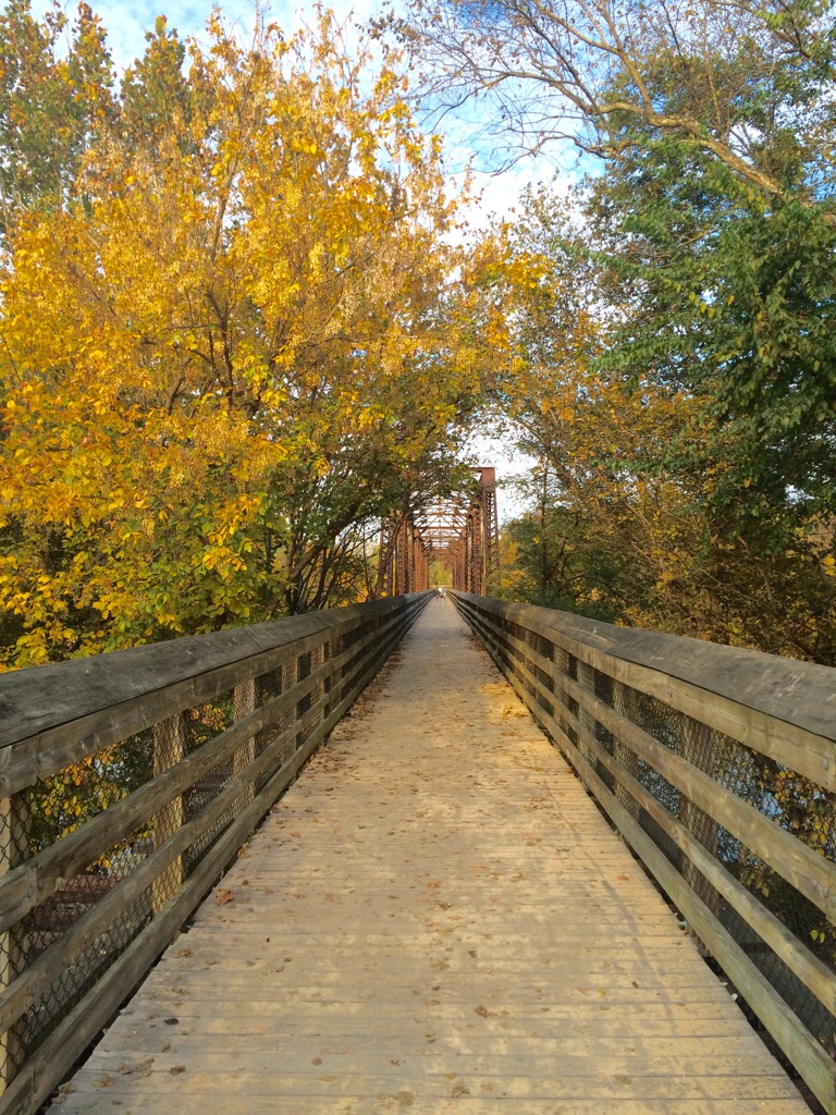
The Crossing at the Dan bike/ped way, pictured here, is one of at least two vital links between the main portion of the River District, located on the south end of the Dan River, and the Danville Riverwalk Trail.
The River District
The River District, comprising the City’s traditional downtown and historic Tobacco Warehouse District, is also a great place to bike. Most of the streets encompassing the River District are not served by dedicated bicycle infrastructure, although sections of Wilson Street are served by bike lanes. The speed limit in the River District is generally 25 MPH, and many of the streets including Wilson, Lynn, Craghead, and Lynn Streets generally carry low traffic volumes, thereby contributing to bicyclist safety and comfort in this popular area of the City. With many new residences, the Danville Farmers’ Market, the Danville Science Center, and numerous restaurants and other destinations, the River District is a great place to ride if you want to get someplace on two wheels quickly. Soon, the River District will boast a new riverfront park, which will likely be a popular destination as well.
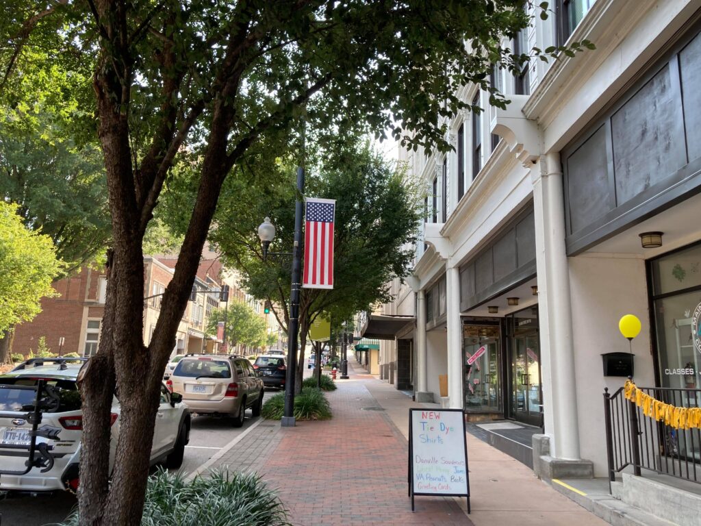
Looking south along South Main Street in the River District.
West Main Street Corridor
The City of Danville has multiple prominent streets served by bike lanes, contributing to cyclist comfort and safety. The first street noted here is a 0.65-mile segment of West Main Street between Stewart Street and Blackwell Drive. The area, served by bike lanes in either direction, is heavily residential – Stewart Street is very close to SOVAH Health – Danville (formerly Danville Regional Medical Center), and Averett University’s Main Campus is located along this segment as well. Additionally, the City’s prominent Ballou Park, can be accessed by continuing west along West Main Street for a short distance, or by using the road network consisting of Blackwell Drive, Magnolia Drive, and Herndon Place.
A bike lane on West Main Street.
Westover Drive Corridor
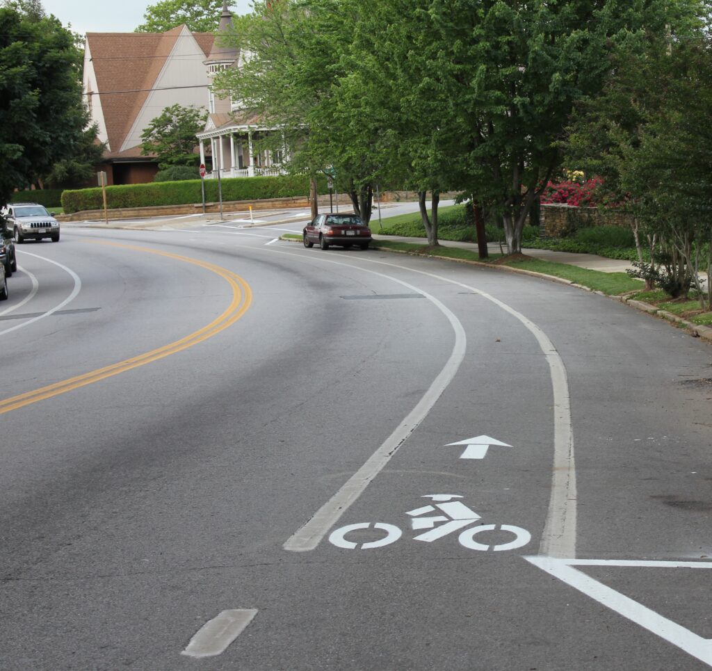
Another street in Danville very well-suited for cycling is Westover Drive, extending east to west within the western end of the City. About one mile of Westover Drive, from approximately 400 feet west of its intersection with Piedmont Drive west to the intersection of Wade Street and Capri Court, is served by buffered bike lanes in both directions. The neighborhoods surrounding Westover Drive are heavily residential, and one can easily bike from any one of these neighborhoods to numerous destinations along Piedmont Drive including the post office, a restaurant, and other establishments. West of its intersection with Wade Street and Capri Court, Westover Drive transitions to four lanes, though it remains predominantly residential and is characterized by relatively low traffic volumes. However, the City commissioned EPR Planning Consultants to conduct a study to determine the best future configuration for the roadway to more effectively accommodate bicyclists, and a conversion of the four-lane section to two travel lanes and two buffered bicycle lanes is what the team recommended. When that project is completed, approximately 5.4 miles of Westover Drive will be continuously served by buffered bike lanes in both directions. More information about the Westover Drive study can be found at https://www.danvilleva.gov/2146/Westover-Drive-Lane-Study.

A buffered bike lane shown on Westover Drive. The buffer provides extra space between the bicyclist and traffic, adding to safety and comfort.
Piney Forest Road Corridor
Beginning this year, EPR was also commissioned by the Danville Metropolitan Planning Organization, which is staffed by the West Piedmont Planning District Commission (WPPDC), to conduct a transportation study on an approximately 2.5-mile segment of Piney Forest Road (U.S. 29 Business) from Holt Garrison Parkway (near Coleman Marketplace) north to Franklin Turnpike. In addition to recommending vehicular safety and functionality improvements along the corridor, the study is also exploring bicycle, pedestrian, and transit improvements. With regard to bicycling, the team early on explored the possibility of recommending a multi-use path directly adjacent to Piney Forest Road, however, the expense of relocating utility poles and other infrastructure rendered that option prohibitively expensive. The study team believed it to be more prudent to recommend a parallel road network as an alternative to the multi-use path. The recommended alternative route (see the image below) consists of a series of parallel residential streets which are generally characterized by a 25 MPH speed limit, making it ideal for bicycling. This tentatively-recommended route network includes, from south to north, Boxwood Court, Piney Forest Road, Woodberry Drive, North Woodberry Avenue, Audubon Drive, Starmont Boulevard, Starmont Drive, Downey Lane, 3rd Avenue West, Arnett Boulevard, Melrose Avenue, Ruskin Street, Nor Dan Drive, and Orchard Drive. This route is significant because the portion of Arnett Boulevard which is recommended to be a segment of the route is scheduled to undergo work this year or next to have bike lanes added on a 0.4-mile segment from Eden Place to Guilford Street. The blue line in the image below depicts where this work will take place. As noted above, this route is heavily residential, and, thus, has the ability to funnel bike traffic from surrounding neighborhoods and direct it to desired locations along the Piney Forest Road corridor, and vice-versa.
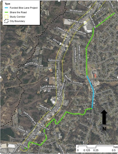
An image of the proposed bicycle route along the Piney Forest Road (U.S. 29 Business) corridor. Source: EPR, PC. “Piney Forest Road Corridor Study.” Danville MPO Meeting, Danville Regional Airport. August 4, 2021.
Whether you bike as part of your commute or other essential trips in Danville, Martinsville, Rocky Mount, Gretna, or Stuart, don’t forget to log your trips in the RIDE Solutions app to earn points toward discounts for shopping, dining, services, or activities, or to enter raffles for the chance to win prizes such as gift cards! The app is completely free to download and to use, and can be found at ridesolutions.org!