

Many of us are familiar with the concept of Complete Streets, but for those who are not, Complete Streets are streets that are designed for all users, whether they are drivers, bicyclists, pedestrians, or transit users. In an urban area or a town, a Complete Street may be a street with traditional travel lanes, bike lanes, sidewalks and crosswalks, and perhaps one or more bus stops if a transit system is present. In a more rural area, a complete street may be a road with an adjacent bike path, or perhaps even a low-traffic country road without any separate accommodations, since a quiet road can accommodate many functions at once, such as driving, bicycling, and walking with minimal conflict.
The West Piedmont Planning District Commission (WPPDC) heads up the West Piedmont Complete Streets Coalition, and as a staff member who serves as its Chair, I make an effort to stay abreast of the latest developments regarding Complete Streets here in the region as well as nationally. In our region, which tends to be rural in most places, promoting and implementing Complete Streets can be especially challenging and sometimes confusing, given the rural nature of roads coupled with considerable distances between population centers. Therefore, the concept is most likely to first succeed in more urban places such as Danville and Martinsville before catching on in and between other places throughout the region. That said, there are some developments that have taken place recently in both urban and rural contexts, and these include the following:
- The Piney Forest Road Corridor Study. The Danville Metropolitan Planning Organization (MPO), administered by the WPPDC, is working with EPR Planning Consultants on a 2.6-mile corridor study along Piney Forest Road in Danville, from Holt Garrison Parkway (near Coleman Marketplace) north to Franklin Turnpike. Among other aspects, the study is putting forth recommendations to improve transit, walkability, and bikeability along the corridor. A transit recommendation will likely consist of a planned transit shelter at a busy stop, and walkability enhancements will include the addition of signalized crosswalks at busy intersections. Due to challenges associated with installing bicycle infrastructure directly along the corridor, the study team identified a set of parallel roadways which have low posted speed limits and pass through mostly residential areas.
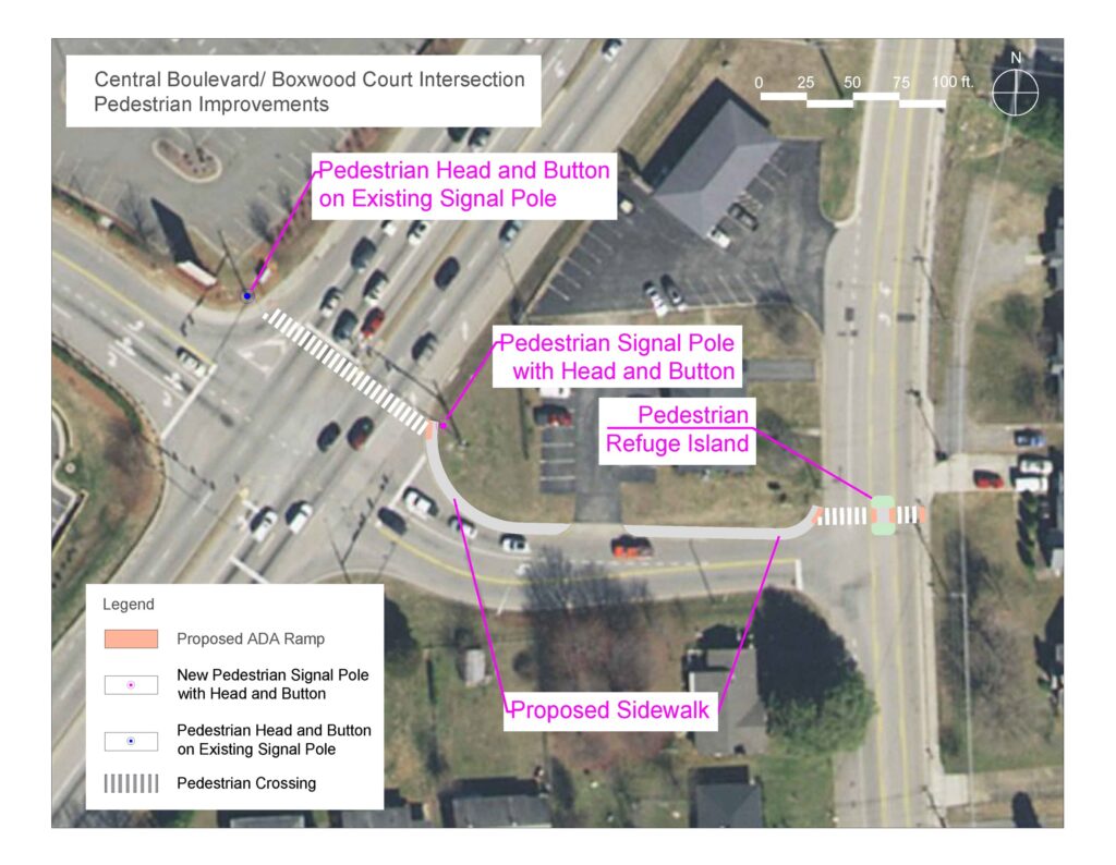
Proposed pedestrian improvements at Piney Forest Road and Boxwood Court in Danville.
- VDOT Project Pipeline Study of Piedmont Drive. The Virginia Department of Transportation (VDOT) has embarked on a study of Piedmont Drive in Danville, between Boxwood Court and Park Avenue. Safety and functionality improvements will be a major part of this study, but bicycle and pedestrian enhancements will be important as well. Improving walkability along the corridor is a priority for the City, as the Danville Mall and other shopping centers are located here, and such infrastructure would make it much easier for people without a vehicle or who would prefer to walk to do so.
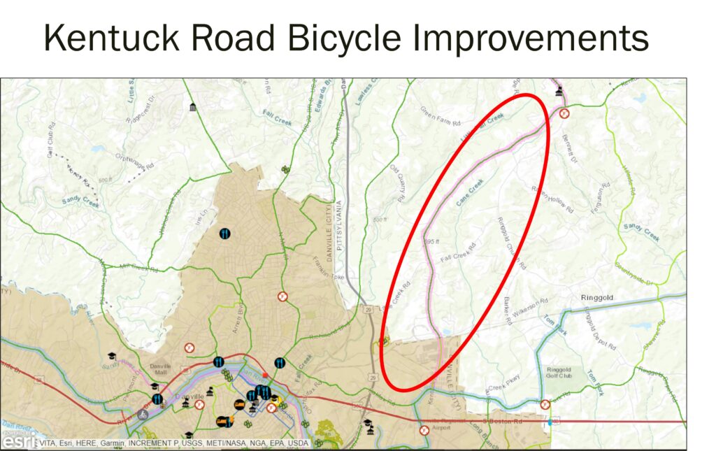
- Kentuck Road Bicycle Improvements. Recently, VDOT approached the Danville MPO to report that several road segments in southern Pittsylvania County were scheduled for repaving, and that extra funding was available for bicycle improvements on road segments on this schedule that corresponded with recommendations within the West Piedmont Regional Bicycle Plan. Using a ranking method, staff selected the Kentuck Road corridor for 2-foot bike lanes to be installed as part of the repaving process. The bike lanes will extend from the Danville City line north (or east) almost to Kentuck Road’s intersection with Kentuck Church Road. These improvements will add bike lanes to nearly five miles of Kentuck Road, which has also been identified by the Regional Bicycle Plan as the Route 29 Priority Corridor, paralleling U.S. Route 29.
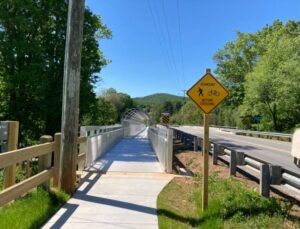
- Ferrum Pedestrian Bridge Completion. The Ferrum pedestrian bridge, located along Route 40 in the Village of Ferrum, Franklin County, was recently completed. This bridge was built parallel to an existing bridge spanning a Norfolk-Southern railroad track near downtown Ferrum, which now enables pedestrians – mostly students of Ferrum College – to walk safely between west Ferrum and establishments east of the bridge. Prior to the bridge construction, pedestrians had to share the roadway with vehicles, putting their safety in jeopardy.
- Martinsville Pedestrian Safety Improvements at Market and Moss Streets. Pedestrian safety improvements were funded at the intersection of Market Street and Moss Street in Martinsville by a successful Smart Scale application submitted by the City in 2020. This location was the scene of a pedestrian fatality in 2019, after which it was determined that pedestrian safety improvements were needed in the area. The enhancements will consist of constructing a crosswalk across Market Street along with a pedestrian refuge, and the construction of two crosswalks spanning Moss Street – one north and one south of Market Street. Other components of the project will include pedestrian-actuated signalization as well as ADA-ramp and sidewalk improvements.
- Improve Walkability from Village of Martinsville Shopping Center to Starling Avenue. The City of Martinsville is working to improve walkability between the Commonwealth Boulevard commercial center (the Village of Martinsville shopping center, in particular) and the Starling Avenue cultural corridor, which houses the Virginia Museum of Natural History and Piedmont Arts. The Commonwealth Boulevard corridor has traditionally been very automobile-oriented, and the City would like to make the corridor more hospitable to pedestrians. Additionally, commercial development housing an internationally-recognized drinking/dining establishment is being constructed across Commonwealth Boulevard from Chick-fil-A, and it is likely that traffic associated with that new development may encourage people to walk across this busy roadway rather than drive; adequate pedestrian infrastructure would help to facilitate that. Ultimately, City officials would like to make the walk from the Commonwealth Boulevard corridor to Starling Avenue – either via uptown or Market Street – much more practical, safe, and enjoyable.
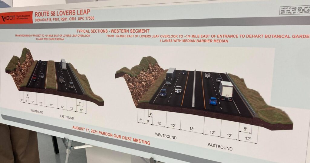
- S. Route 58 Widening from Stuart to Lovers Leap in Patrick County. This fall, construction is scheduled to begin on the mountainous two-lane segment of U.S. Route 58 from just west of Stuart to just west of the Lovers Leap overlook – a total distance of 7.4 miles. The $300 million project will widen the two-lane highway to four lanes, which will be median separated in most locations; will improve grades and geometry; and will result in a new separated Lovers Leap overlook with parking. With respect to complete streets, widened shoulders will make it safer and more comfortable for bicyclists to ride along the roadway between the Town of Stuart and the Blue Ridge Parkway. All construction is anticipated to be completed by spring 2026.
Complete Streets Legislation
There are currently two pieces of proposed legislation that have been introduced to Congress to advance Complete Streets at the federal level. As of this time, the two pieces of legislation have been introduced but have not yet been voted on. The two proposals include the following:
- The Complete Streets Act of 2021 (H.R. 1289). This proposed law would require states to adopt a competitive grant process which would fund the technical assistance, design, and construction necessary to develop complete streets.
- Mobility Options, Resiliency, and Efficiency (MORE) through TDM Act (H.R. 6770). This proposed legislation would support
“[T]ransportation demand management (TDM) expectations and goals that will serve the mobility needs of the people and freight, foster economic growth and development within and between states and urbanized areas. (Transportation demand management is the use of strategies to inform and encourage travelers to maximize the efficiency of a transportation system leading to improved mobility, reduced congestion, and lower vehicle emissions.).”[1]
Transportation Demand Management (TDM) simply means utilizing a variety of strategies to manage demand on the transportation system, usually a roadway. On an urban highway, for instance, TDM might consist of dynamic tolling at various times of the day to influence travel patterns, as well as bus rapid transit and perhaps rail service. For a transportation corridor in a smaller city or town which experiences periodic congestion at certain times of the day, TDM may consist of park and ride lots to encourage carpooling, transit service, bicycle lanes or a multi-use path to encourage bicycling, and upgraded sidewalks and crosswalks to promote walking short distances.
The MORE through TDM Act would require that:
- TDM targets be established at the state and metropolitan planning levels.
- The bill would also direct the U.S. Department of Transportation (DOT) to create a program to facilitate the development of TDM actions via encouragement, assistance, and funding mechanisms.
- Through this legislation, the DOT would furnish grants to not-for-profit institutions of higher learning to establish research centers pertaining to TDM strategies.
- A National Advisory Committee would be established by the legislation to channel federal policies and resources to the development of TDM goals.
Regardless of whether your commutes or essential trips are accomplished by bicycle, walking, transit, carpooling, or you telework, don’t forget to log your trips or telework sessions into the RIDE Solutions app to earn points toward discounts on shopping, dining, activities, or services, or for the opportunity to enter raffles to win great prizes such as gift cards! You can download the app for FREE at ridesolutions.org!
[1] Mobility Options, Resiliency, and Efficiency (MORE) through TDM Act. H.R. 6770. 116th Congress. 5/11/2020.