

If you regularly walk in your neighborhood or somewhere in your community, you are likely very familiar with how walkable or bikeable it is. If you are wondering how walkable or bikeable your neighborhood is, or a place you would like to walk or bike is, a great resource is Walk Score. Similarly, the AARP (American Association of Retired Persons) Livability Index is another excellent resource which can show you a number of aspects of the quality of a neighborhood’s transportation system. AARP’s Livability Index, however, goes beyond Walk Score, to include many other aspects of a community’s or neighborhood’s transportation system, as well as other quality of life indicators.
In terms of walkability, each community has areas and neighborhoods which are more walkable than others. For example, Rocky Mount is more walkable than Union Hall, Stuart is more walkable than Woolwine, and Danville’s River District is more walkable than the western part of that city. A similar dynamic is observed for bikeability, though bicycle-friendliness may be more subjective than walkability due to the variety of preferred types of bicycle infrastructure. For instance, some bicyclists may be most comfortable riding on a city or town street with low posted speed limits and bike lanes, while other cyclists may prefer a scenic rural road with little traffic.
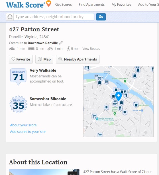
Walk Score is an excellent resource by which to determine walkability and bikeability. Simply navigate to www.walkscore.com, and you are given a space to input your town, city, or address. Undoubtedly one of the most walkable places in the U.S. is New York City, and if we enter in 695 Park Avenue (Hunter College, where I studied Urban Planning), we’ll see that it scores 99 (out of 100). In terms of transit, it scores 100 due to the plentiful transit options available, such as a nearby subway stop as well as the proximity of bus routes. This address scores 62 out of 100 for bikeability. Let’s take a look at the City of Danville’s municipal building, located at 427 Patton Street, which falls within the River District. In terms of walkability, Walk Score scores this address as 71, which it considers “Very Walkable.” In terms of bikeability, the address scores 35, or “Somewhat Bikeable.”
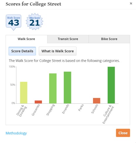
Let’s take a look at a smaller location in the West Piedmont Region – the Town of Rocky Mount. Specifically, we’ll look at the Rocky Mount Farmers’ Market, which is listed as College Street in Rocky Mount. College Street ranks 43 in terms of walkability and 21 in terms of bikeability. In terms of the lower walkability score, Walk Score provides the following data:
As noted above, AARP provides a Livability Index, which encompasses various elements in addition to transportation, such as Housing, Neighborhood, Environment, Health, and Engagement. Since many Americans who are getting close to retirement age are choosing to relocate to walkable town and city centers with various amenities close at hand, the AARP Livability Index may be a good option for these individuals to look at.
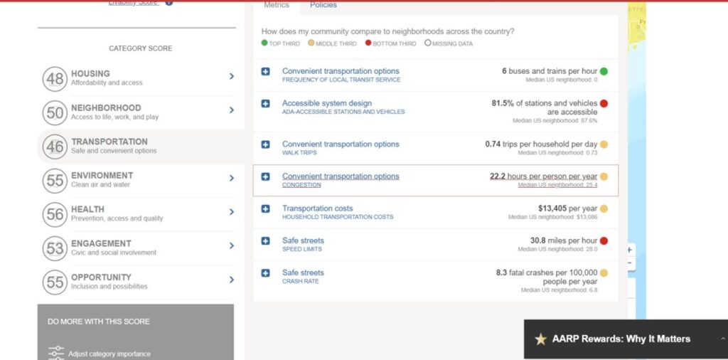
Using AARP’s Livability Index, let’s look at Starling Avenue in Martinsville, which is within walking distance of the City’s uptown area, the Blue Ridge Public Library, as well as a number of cultural venues such as the Virginia Museum of Natural History and Piedmont Arts. The Livability Index score of Starling Avenue is 52. This includes 48 for Housing Affordability, 50 for Neighborhood, 46 for Transportation, 55 for Environment, 56 for Health, 53 for Engagement, and 55 for Opportunity. Each metric shown here is expandable, enabling the viewer to dissect the data which it comprises. For example, Transportation is shown as 46, and if we click on this metric shown in the image below, we see that each sub-metric is shown as top third, middle third, or bottom third. Additionally, each of the Transportation sub-metrics include:
- Convenient Transportation Options – Frequency of Local Transit Service
- Accessible System Design – ADA-Accessible [transit] stations and vehicles
- Convenient Transportation Options – Walk Trips
- Convenient Transportation Options – Congestion
- Transportation Costs – Household Transportation Costs
- Safe Streets – Speed Limits
 The Neighborhood metric of the AARP Livability Index also includes certain elements directly or indirectly associated with transportation. For example, some of these metrics include “Proximity to destinations – access to jobs by transit,” “Proximity to destinations – access to jobs by auto,” Compact neighborhoods – activity density,” and others.The AARP Livability Index can be accessed at https://livabilityindex.aarp.org/.These two resources are excellent with regard to learning how walkable or bikeable a locality or neighborhood is if you plan to visit, move there, or are just curious. The AARP Livability Index, again, offers a number of additional metrics to learn about how livable a place is.
If your commute or other essential trips involve walking, biking, using transit, teleworking, or carpooling, don’t forget that you will earn points toward rewards each time you log a trip in the RIDE Solutions app! Rewards consist of discounts on dining, shopping, activities (such as entertainment), and services, as well as opportunities to enter raffle contests. Download the RIDE Solutions app for FREE today at ridesolutions.org!