

I have written a number of blogs concerning bicycling in the West Piedmont Region, which consists of Franklin, Henry, Patrick, and Pittsylvania counties, the cities of Danville and Martinsville, and the Town of Rocky Mount. I have also referenced the West Piedmont Regional Bicycle Plan in a number of those blogs. This regional bicycle plan will be the focus of today’s blog, and I will show you how to use the interactive map feature of this great resource to plan your next bike trip!
The West Piedmont Regional Bicycle Plan was adopted by the Board of the West Piedmont Planning District Commission (WPPDC) in February 2018, and serves as an update to the original regional bicycle plan, adopted in 2005. A main portion of the regional bicycle plan is a compendium of recommended bicycle routes. Like its 2005 predecessor, the 2018 plan proposes a network of recommended routes by locality, based on a number of factors. The factors used to determine recommended cycling routes for the 2018 plan included observing bicyclists’ preferred routes using Strava maps, meetings with local planners, reviewing traffic volume data (in the form of annual average daily traffic) average number of trucks per day to identify roads with low traffic and truck volumes, percent grade to ensure that routes are reasonable in their topography, and speed limits to help ensure comfortable rides for cyclists. WPPDC staff also visited many of these routes to observe how accommodating or challenging they were to cyclists, as well as to determine vehicle sight distance to as to help to maintain safety for bicyclists. Many recommended routes were also carried over from the 2005 plan.
Unlike the 2005 plan, the 2018 plan includes two priority routes and a priority zone. The Beaches to Bluegrass Priority Route generally follows the planned alignment of the Beaches to Bluegrass Trail, developed by the Virginia Department of Conservation and Recreation (DCR), and is proposed to extend from Cumberland Gap, Tennessee east to Virginia Beach. The route passes, from west to east, through Patrick, Henry, and Pittsylvania counties, and the cities of Danville and Martinsville. This route is meant to serve largely as an alternative to heavily-trafficked U.S. Route 58.
The Alternate U.S. 29 Priority Route generally parallels U.S. Route 29, and extends from Danville in the south to the Town of Hurt in the north, utilizing lightly-traveled paved and gravel roads throughout Pittsylvania County. The Western Franklin County Priority Zone covers approximately 249 square miles in the western portion of Franklin County. This was developed by the WPPDC, with recommendations from Franklin County staff, as the western half of Franklin County is very rural with lightly-traveled roads and outstanding scenery.
The remainder of this blog will describe the interactive map feature, as well as how to use it. To access the map feature of recommended bicycle routes in the West Piedmont Regional Bicycle Plan, visit https://wppdc.maps.arcgis.com/apps/View/index.html?appid=abfe3df1b6ec4769aff2253d528fe2e9&extent=-80.3966,36.5503,-79.3420,37.0073. This view will present you with an overview of the region and its many recommended bicycle routes.
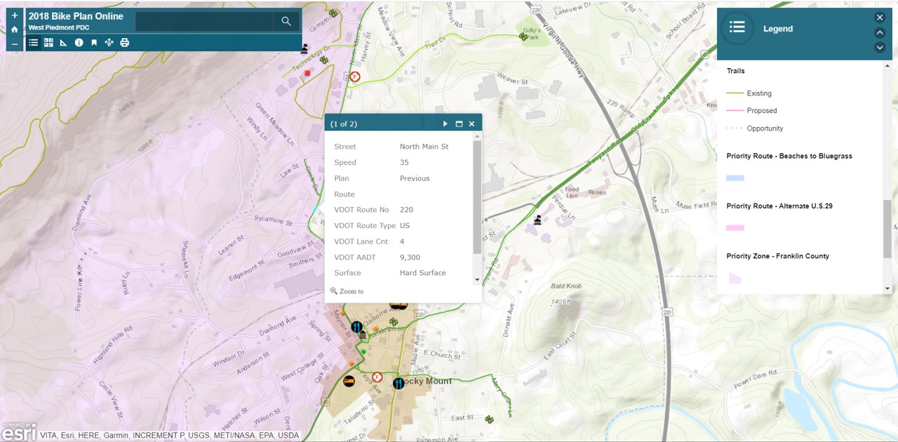
Let’s say you live in the Town of Rocky Mount and you’d like to use the bike plan to ride to Gilly’s Park, located in the northeast part of the town. You would zoom in to Rocky Mount and locate green lines which represent the recommended bicycle routes between your point of origin and your destination. You can click on any segment of a green line and a menu will pop up which will provide information about that route segment. Information provided includes the route name and number; posted speed limit expressed as “Speed;” the number of travel lanes; daily traffic volume expressed as “VDOT AADT,” or annual average daily traffic; the surface type (hard surface or gravel); and the County the route is located in. This will help you determine how suitable a particular route is for you to ride. The image below depicts this menu for North Main Street (U.S. Route 220 Business) in the Town of Rocky Mount.
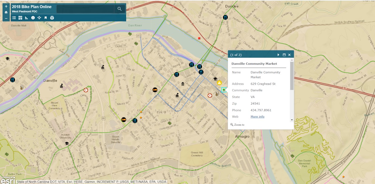
When this interactive map was created, an effort was made to include prominent destinations which may be attractive to bicyclists, and these are clickable for identification purposes as well. We included such destinations as wineries, breweries, distilleries, libraries, parks, YMCAs, farmers’ markets, restaurants, campsites, bed & breakfasts, points of interests, and others. The source of many of these destinations was Virginia’s West Piedmont Local Foods Guide, and this is important because the pairing of resources within this Local Foods Guide with the Regional Bicycle Plan made efficient use of both documents and affords opportunities for bicyclists to explore destinations in our region, and simultaneously facilitates economic development in our region. The image below shows an example of prominent destinations in the City of Danville, with the Danville Community Market selected. As can be seen, a menu box pops up showing the name of each destination, its address, phone number, and website. The Virginia’s West Piedmont Local Foods Guide can be found at http://www.wppdc.org/documents-publications/economic-development.
If you bicycle as part of your work commute or for other essential trips or if you plan to as summer arrives, don’t forget that you can earn points toward great rewards by logging all of your bicycle trips into the RIDE Solutions app. This app is available for free at ridesolutions.org!