

In recent months, I have been writing blogs for those who may wish to bicycle as part of their commute or to take other trips, such as those to go shopping, or to access medical appointments, entertainment, or dining. This blog is a follow-up to a blog I posted at the end of December, entitled New Year’s Resolution: “Bicycling is a Great Way to Get in Shape, Save Money, Help the Environment, and Get Rewarded for it!” (see https://ridesolutions.org/2020/12/30/new-years-resolution-bicycling-is-a-great-way-to-get-in-shape-save-money-help-the-environment-and-get-rewarded-for-it/). In that blog, I referenced a variety of articles touting the many health benefits of bicycling. In addition to these benefits, I noted that bicycling can save money, wear-and-tear on vehicles, and has virtually no environmental impact. Bicycling is certainly among the most enjoyable workouts one can engage in, and when this workout is incorporated into the commute or other trips, much more time is made available for other activities one may wish to engage in, such as extra time with family, etc. Spring has arrived, and with its moderately warm temperatures and the re-emergence of delightful plant life and budding trees, it is a great time to get out and take advantage of all that nature has to offer. Therefore, now is a great time to get your bike in working order as everything springs (pun intended) back to life! While one of my earlier blogs focused on bicycling in and around the Town of Rocky Mount, this week’s blog will focus on other areas of Franklin County.
The Town of Rocky Mount, centrally located in Franklin County along the U.S. Route 220 corridor, is the largest community in the County as well as the county seat and the main seat of commerce. Other population and activity centers in the County include the Village of Ferrum, the Town of Boones Mill, Westlake Center, and the Callaway community. In addition, there is a number of smaller communities such as Burnt Chimney, Union Hall, Penhook, Wirtz, and others. These communities are interspersed among lands that are generally rural, agricultural, and wooded throughout the County. The western half of the County is more rugged than the eastern half and is bordered by the Blue Ridge Mountains and the Parkway that bears this mountain range’s name. While the County’s rural character presents challenges to bicycling owing to greater distances between population centers, that same aspect presents opportunities such as views of pastoral landscapes and lower traffic volumes, particularly in the western part of the County.
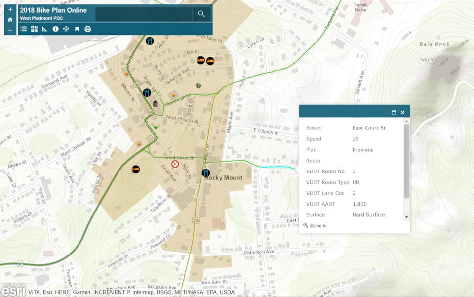
If you’re considering getting on your bike to get to work or to go shopping, dining, or to access another destination, a great resource to help you choose your route is the interactive map feature of the West Piedmont Regional Bicycle Plan, available at https://wppdc.maps.arcgis.com/apps/View/index.html?appid=abfe3df1b6ec4769aff2253d528fe2e9&extent=-80.3966,36.5503,-79.3420,37.0073. This interactive map comprises a network of recommended bicycle routes throughout Franklin County (and the West Piedmont Planning District), which can help you plan to get to where you’d like to go. The figure below is a screenshot from this interactive map demonstrating how it works. The green lines superimposed over the roadways represent recommended bike routes. Each segment of these routes is clickable, and when one is selected, a menu will pop up which displays characteristics of a particular route such as posted speed limit, traffic volume expressed as AADT (Annual Average Daily Traffic), the number of travel lanes, and road surface material (asphalt or gravel).
The following sections describe various centers in Franklin County, and suggested bike routes to access them.
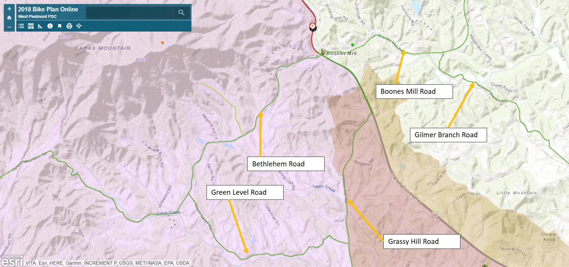
Town of Boones Mill
The Town of Boones Mill, located along the U.S. Route 220 corridor in the north end of Franklin County, is a residential and employment center, which is also becoming a focal point for breweries and distilleries. Approaching Boones Mill from the east, the West Piedmont Regional Bicycle Plan’s interactive map recommends Boones Mill Road, as well as the road pair consisting of Gilmer Branch Road and Rock Lily Road. Traffic, expressed as AADT, on Boones Mill Road is not shown in the Regional Bicycle Plan, however, it is relatively moderate at 1,700 – 1,900 vehicles per day; traffic volumes on the road pair Gilmer Branch and Rock Lily Roads are significantly lower. Approaching town from the west, Bethlehem Road is recommended. As is the case with Boones Mill Road, traffic volumes are not shown for Bethlehem Road, but they range from 1,500 vehicles per day several miles west of Boones Mill to 3,000 vehicles per day when coming into town. From the south, the Regional Bicycle Plan recommends using Grassy Hill Road to Green Level Road to Bethlehem Road, which will lead you right into town.
Westlake Corner
Westlake Corner serves the Smith Mountain Lake community as a center for shopping, health care, and culture. The area is home to the Booker T. Washington National Monument, named after the influential African-American Booker T. Washington, who founded the Tuskegee Institute, among other accomplishments, following the abolition of slavery. While recommended bicycle routes within the West Piedmont Regional Bicycle Plan’s interactive map are relatively scarce in the Westlake Corner area, options do abound. Route 122 (Booker T. Washington Highway), approaching from the east or west, is an option, though cyclists should exercise caution due to high traffic volumes on this road. From the southwest, the Regional Bicycle Plan recommends Brooks Mill Road. Many residential communities are found along the north end of Westlake Corner, and the residential roads leading from these communities to the commercial heart of Westlake, serve as great bike routes. In the coming years, multi-use paths will be constructed in the Westlake area, making the area much more walkable and bikeable. For instance, such a trail is scheduled to be constructed between Westlake Village Center and the Booker T. Washington National Monument. Another multi-use trail is scheduled to be constructed along U.S. Route 220 from Lost Mountain Road east to an existing sidewalk located east of the Booker T. Washington National Monument.
Wirtz
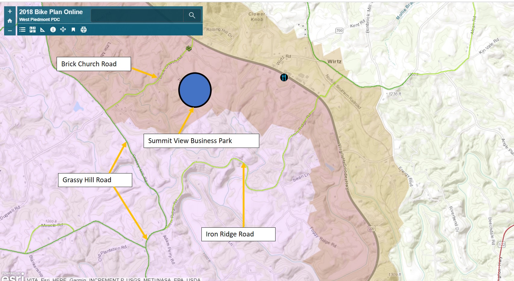
The Wirtz community, located north of the Town of Rocky Mount, is a commercial cluster comprising various types of establishments along the U.S. Route 220 corridor. Additionally, the new Summit View Business Park is located just north of Wirtz, immediately west of U.S. Route 220, and promises to be a major regional employment center when fully developed. Approaching Wirtz from the north or south, Grassy Hill Road is a recommended route within the interactive map feature of the West Piedmont Regional Bicycle Plan; this road also serves the Summit View Business Park, via Brick Church Road. Approaching Wirtz from the northeast, Rock Lily Road is a recommended route in the Regional Bicycle Plan. Approaching Wirtz from the west, Iron Ridge Road is a recommended route; Iron Ridge Road intersects Grassy Hill Road, enabling cyclists to transition both north and south as well. Approaching Wirtz from the east, the road network consisting of Wirtz Road, Angle Plantation Road, and Alean Road, are all recommended via the Regional Bicycle Plan.
Village of Ferrum
The Village of Ferrum, located in southwestern Franklin County, is a small population center comprising residences and small-scale businesses, but is most closely associated with its status as a college town, serving as home to Ferrum College. The Blue Ridge Institute and Museum, which is associated with Ferrum College, showcases the culture of the Blue Ridge Region, and is located in the Village alongside Ferrum College. Due to its relatively small size and location in rural western Franklin County, biking into the village for work, school, shopping, or health needs, is generally comfortable due to relatively low traffic volumes in the area. Based on the interactive map feature of the West Piedmont Regional Bicycle Plan, the recommended route to approach the village from the east is via Old Ferrum Road, which parallels the more highly-trafficked Route 40 just to its south. Approaching the village from the north, the Regional Bicycle Plan recommends Ferrum Mountain Road and Turners Creek Road, both of which are characterized by very low traffic volumes on most of their lengths. Approaching the village from the south, the Regional Bicycle Plan recommends Ingramville Road and Prillaman Switch Road, both of which are characterized by traffic volumes (expresses as AADT) below 1,000 daily. Other viable routes when approaching the village from the south include Timber Line Road and Marshall Hill Road, both of which are characterized by very low traffic volumes; please note that Timber Line Road is gravel-surfaced. Approaching the village from the west, the Regional Bicycle Plan recommends using Route 40, which is characterized by traffic volumes of about 1,500 vehicles daily. The image below presents a map of the routes listed herein.
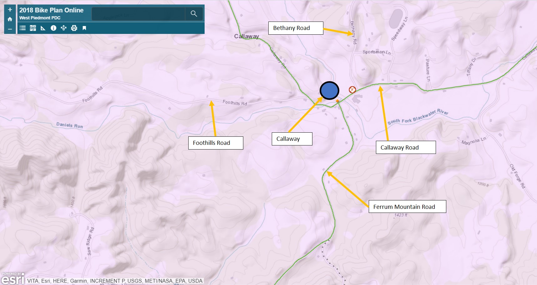
Callaway
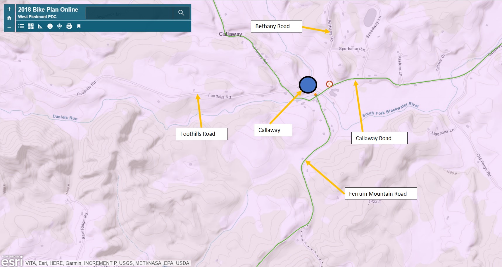
Callaway is a small village-type center located in pastoral western Franklin County, situated north of the Village of Ferrum. This center is very small and mostly consists of scattered residences, independently-owned businesses, local churches, an elementary school, and the Franklin County Speedway. Given the very rural character of Callaway and the surrounding area, bicycling to this center for work, shopping, church, or another purpose, should be very comfortable for most bicyclists owing to the low traffic volumes and beautiful scenery. When approaching Callaway from the north or east, the interactive map feature of the West Piedmont Regional Bicycle Plan recommends using Callaway Road. An alternative to Callaway Road when approaching from the north is Bethany Road, which is characterized by traffic volumes of less than 700 vehicles per day. Approaching Callaway from the south, the road pair consisting of Ferrum Mountain Road and Five Mile Mountain Road are recommended via the Regional Bicycle Plan. Approaching Callaway from the west, Foothills Road would be a great route, given the fact that its traffic volume is only about 210 vehicles per day. See the figure below for a map view of these routes.
If you live in Franklin County and you are currently bicycling as part of your commute or to access shopping, entertainment, dining, or another type of destination, remember that you will earn points toward great rewards by logging every bicycle trip you take into the free RIDE Solutions app, available at ridesolutions.org!