

In early 2018, the West Piedmont Planning District Commission adopted the West Piedmont Regional Bicycle Plan, an update to the first bicycle plan adopted by the Commission in 2005. This plan is divided into two sections – the planning document and the interactive map, the latter of which lays out recommended routes that may be adopted by localities in the region.
The planning document actually serves as an excellent resource for bicyclists and localities in many ways. Chapter 2, for instance, ties bicycling to both economic development and public health. This chapter provides examples of how bicycling can enhance the economy of the West Piedmont Planning District, while articulating the many health benefits of bicycling, both physical and mental. This chapter is indispensable to local officials looking to promote economic development or enhance public health in their communities.
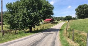
Chapter 3 contains an exhaustive list of bicycling resources in the region, such as road sections with rideable shoulders or bike lanes/sharrows, multi-use trails, and mountain biking trails. In addition, this chapter contains a section pertaining to current planning activities relating to bicycle infrastructure. This chapter would be beneficial to anyone who lives in or would like to visit the region for the purpose of bicycling, and is looking for trails to bike on.
Chapter 4 could be considered the heart of the planning document, as it contains an extensive list of recommendations – both Priority and Vision – by which to promote bicycling in individual localities as well as in the region as a whole. Priority Recommendations are those that may be deemed to be the most desirous regional or local recommendations, be the most feasible to implement, or have a strong likelihood of being funded. Vision recommendations, by contrast, are those recommendations that are more aspirational in their likelihood or desire to be implemented. The planning document can be found at http://www.wppdc.org/content/wppdc/uploads/PDF/docs_publications/transportation/wppd__regional_bicycle_plan_final.pdf.
The second part of the regional bicycle plan, as noted earlier, is an interactive map. This online map features clickable road layers by which bicyclists can see the road’s posted speed limit, the surface type (paved or unpaved), and average traffic volume expressed as Annual Average Daily Traffic (AADT). This map also includes destinations for bicyclists to ride to, such as breweries and wineries, parks, farmers’ markets, dining establishments, campgrounds, among others. When a user of the site clicks on one of the icons representing such a destination, information about it will pop up. Please see additional information on the interactive map portion of this plan at https://wppdc.maps.arcgis.com/apps/View/index.html?appid=abfe3df1b6ec4769aff2253d528fe2e9&extent=-80.3966,36.5503,-79.3420,37.0073.